 Filter: Categories of Wisconsin Historical Images
Filter: Subject of Wisconsin
Filter: Subject of transportation
Filter: Categories of Wisconsin Historical Images
Filter: Subject of Wisconsin
Filter: Subject of transportation

| Date: | 1920 |
|---|---|
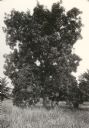
| Description: | View of a supposed Indian "trail tree," on former Mercer's addition or subdivision, now the corner of Elm and Van Hise Streets near Madison West High Schoo... |
| Date: | 1920 |
|---|---|
| Description: | View of a supposed Indian "trail tree," on former Mercer's addition or subdivision, now the corner of Chestnut and Van Hise Streets, near Madison West High... |

| Date: | 1920 |
|---|---|
| Description: | View of a supposed Indian "trail tree" on former Mercer's addition or subdivision, now the corner of Chestnut and Van Hise Streets, near Madison West High ... |

| Date: | |
|---|---|
| Description: | View of a supposed Indian "trail tree" on former Mercer's addition or subdivision, now the corner of Elm and Van Hise Streets, near Madison West High Schoo... |
| Date: | 1913 |
|---|---|
| Description: | Portrait of Chippewa (Ojibwa) man at Bad River Indian Reservation. |
| Date: | |
|---|---|
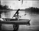
| Description: | Ho-Chunk man in a canoe on a river holding up an oar. Just out of frame on the left is a woman, who is perhaps holding a child. |

| Date: | |
|---|---|
| Description: | Ho-Chunk man performing a handstand in front of two Ho-Chunk men standing on the left. There is a child sitting in one of several horses horse-drawn wagons... |

| Date: | |
|---|---|
| Description: | Ho-Chunk man performing a handstand in front of two Ho-Chunk men standing nearby. There is a horse-drawn wagon near trees and bushes in the background. |

| Date: | |
|---|---|
| Description: | Five Ho-Chunk men are sitting around a blanket on the ground playing cards. They are in front of a lodge frame without coverings. A man holding a walking s... |

| Date: | |
|---|---|
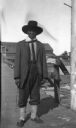
| Description: | View down wooden sidewalk towards a Ho-Chunk man smoking a cigar and wearing a duck bone breast plate and fur pants on the left, and a European American ma... |
| Date: | 1838 |
|---|---|
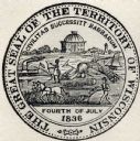
| Description: | Territorial seal of Wisconsin. There is a farmer in the foreground plowing behind horses, a Native American apparently heading west, a river steamboat and ... |

| Date: | 1688 |
|---|---|
| Description: | This map includes vignettes of Amerindian life with text describing geography, culture, and exploration activity, written in French. The Great Lakes, river... |
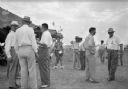
| Date: | 1940 |
|---|---|
| Description: | Men in summer clothes stand in small groups outside of a large canvas tent. The men on the right wear badges with ribbons. In the background, a man in Nati... |
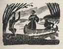
| Date: | 1941 |
|---|---|
| Description: | Woodcut illustration of a missionary priest wearing a robe standing in the fore of a canoe as it comes ashore paddled by a person in the aft. An Indian on ... |

| Date: | 1930 |
|---|---|
| Description: | This map shows Indian trails through Wisconsin counties. The trail are in red ink. Lake Michigan, Green Bay, Lake Superior, and the Wisconsin River are lab... |

| Date: | |
|---|---|
| Description: | Letterhead of the Kewaskum Mutual Fire Insurance Company of Washington County, Wisconsin, with a Native American man wearing buckskin clothes and leggings ... |

| Date: | 1943 |
|---|---|
| Description: | A map that shows the lands for sale by the Tomahawk Land Company of Tomahawk, Wisconsin, in the counties of Langlade, Lincoln, Oneida, and Price. The map s... |

| Date: | 1937 |
|---|---|
| Description: | Label submitted to the state of Wisconsin for trademark registration. "Pioneer Beer, G. Weber Brewing Co." Under this in the center is a leaf with the lett... |

| Date: | 1880 |
|---|---|
| Description: | A hand-colored map of the Chippewa, Price, Taylor and the northern part of Clark counties, which shows the locations of farmhouses, schoolhouses, churches,... |

| Date: | 1864 |
|---|---|
| Description: | This map of the entire state of Wisconsin depicts the township survey grid and identifies counties, named towns, cities and villages, rivers, lakes, railro... |
If you didn't find the material you searched for, our Library Reference Staff can help.
Call our reference desk at 608-264-6535 or email us at: