 Filter: Categories of Wisconsin Historical Images
Filter: Subject of Wisconsin
Filter: Subject of transportation
Filter: Subject of service industries
Filter: Categories of Wisconsin Historical Images
Filter: Subject of Wisconsin
Filter: Subject of transportation
Filter: Subject of service industries

| Date: | |
|---|---|
| Description: | Map reads: "Historic and Scenic Wisconsin — Land of Gathering Waters." In an inset there is a hand-painted depiction of the Wisconsin State Seal. For some ... |
| Date: | |
|---|---|
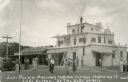
| Description: | Exterior view of Parson's Indian Village, a tourist attraction on Highway 12 styled after a Zuni pueblo. Caption reads: "Zuni Pueblo-Parson's Indian Villag... |

| Date: | |
|---|---|
| Description: | Back, front, and inside front cover of the menu from The Restaurant at Baron's department store, with "A Historical Map of Madison" focusing on the isthmus... |

| Date: | 1939 |
|---|---|
| Description: | This illustrated map shows counties, highways, rivers, roads, present and proposed state parks and forests, proposed state parkways, proposed state monumen... |

| Date: | |
|---|---|
| Description: | A night view of automobiles in the parking lot at the Stand Rock Amphitheater, where the Stand Rock Indian Ceremonial is performed. |

| Date: | 1930 |
|---|---|
| Description: | View across muddy ground towards a man holding a dairy cow by the halter, and on the left a boy holding the lead of a heifer. They are standing in front of... |

| Date: | 1980 |
|---|---|
| Description: | The general theme of this black and white map is "Discover and Enjoy Wisconsin." The front of the map depicts driving tours numbered 1 through 12; each to... |
If you didn't find the material you searched for, our Library Reference Staff can help.
Call our reference desk at 608-264-6535 or email us at: