 Filter: Categories of Wisconsin Historical Images
Filter: Subject of Wisconsin
Filter: Subject of trails
Filter: Subject of human settlements
Filter: Categories of Wisconsin Historical Images
Filter: Subject of Wisconsin
Filter: Subject of trails
Filter: Subject of human settlements

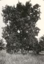
| Date: | 1920 |
|---|---|
| Description: | View of a supposed Indian "trail tree," on former Mercer's addition or subdivision, now the corner of Elm and Van Hise Streets near Madison West High Schoo... |
| Date: | 1920 |
|---|---|
| Description: | View of a supposed Indian "trail tree," on former Mercer's addition or subdivision, now the corner of Chestnut and Van Hise Streets, near Madison West High... |

| Date: | 1920 |
|---|---|
| Description: | View of a supposed Indian "trail tree" on former Mercer's addition or subdivision, now the corner of Chestnut and Van Hise Streets, near Madison West High ... |

| Date: | |
|---|---|
| Description: | View of a supposed Indian "trail tree" on former Mercer's addition or subdivision, now the corner of Elm and Van Hise Streets, near Madison West High Schoo... |

| Date: | 1930 |
|---|---|
| Description: | This map shows Indian trails through Wisconsin counties. The trail are in red ink. Lake Michigan, Green Bay, Lake Superior, and the Wisconsin River are lab... |

| Date: | 1922 |
|---|---|
| Description: | A map of Iron County, Wisconsin, shows sections and the towns of Upson, Hurley, Hamilton, Saxon, and Mercer, lakes and streams, villages, railroads, roads ... |

| Date: | 1949 |
|---|---|
| Description: | This pictorial map shows the United States west of the Mississippi, including Indian Tribes, historic trails, forts, trading posts, mountain ranges, lakes ... |
If you didn't find the material you searched for, our Library Reference Staff can help.
Call our reference desk at 608-264-6535 or email us at: