 Filter: Categories of Wisconsin Historical Images
Filter: Subject of Wisconsin
Filter: Subject of industries
Filter: Categories of Wisconsin Historical Images
Filter: Subject of Wisconsin
Filter: Subject of industries

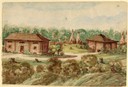
| Date: | 1910 |
|---|---|
| Description: | Sawmill on a Menominee Indian reservation, with logs floating in the water in the foreground. Caption reads: "Menominee Indian Mills." |
| Date: | 1858 |
|---|---|
| Description: | This house was located among the Chippewa (Ojibwa) Indians. Here Hölzlhuber and his companions took shelter in an uncomfortable stable one night, after an ... |
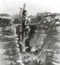
| Date: | 1855 |
|---|---|
| Description: | "Ancient copper mining on Lake Superior." |
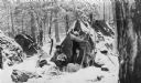
| Date: | 1920 |
|---|---|
| Description: | Vicinity of the New Dells Lumber Company logging camp. Chippewa family on a snowy day at their camp site. |
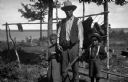
| Date: | 1907 |
|---|---|
| Description: | View towards a man standing with two children, a boy wearing a hat and suspenders, and a girl wearing a dress. They are standing in front of a bear hide st... |

| Date: | |
|---|---|
| Description: | David Goodvillage (WauHeTonChoEKah), standing with his horse who is loaded with supplies, including cattail mats, snowshoes and canvases, for a hunting and... |
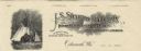
| Date: | |
|---|---|
| Description: | Letterhead of the J.S. Stearns Lumber Company of Odanah, Wisconsin, manufacturers of "Indian Reservation Soft Pine and Norway Lumber" and general merchandi... |

| Date: | 1845 |
|---|---|
| Description: | This map shows lakes, rivers, Chippewa land, the U.S. Mineral Land Agency, boundary between U.S. and Canada, Methodist and Catholic missions, and American ... |

| Date: | 1949 |
|---|---|
| Description: | This pictorial map shows the United States west of the Mississippi, including Indian Tribes, historic trails, forts, trading posts, mountain ranges, lakes ... |

| Date: | 1974 |
|---|---|
| Description: | Map of Wisconsin with drawings illustrating historic places and events throughout the state. The Great Seal of the State of Wisconsin appears at the top ri... |

| Date: | |
|---|---|
| Description: | Cigar box cover with a head and shoulders portrait of Nelson Dewey. Beneath his portrait is a Native American headdress, a tomahawk, a stone club and a qui... |

| Date: | 1937 |
|---|---|
| Description: | Pictorial map showing historical events and locations within the state of Wisconsin, as well as waterways and counties. Original caption on the bottom marg... |

| Date: | 1720 |
|---|---|
| Description: | Map showing the course of the Mississippi River from the Gulf of Mexico up past Lake Superior into Canada. It shows the towns, Native American tribes and l... |
If you didn't find the material you searched for, our Library Reference Staff can help.
Call our reference desk at 608-264-6535 or email us at: