 Filter: Categories of Wisconsin Historical Images
Filter: Subject of Wisconsin
Filter: Subject of education
Filter: Categories of Wisconsin Historical Images
Filter: Subject of Wisconsin
Filter: Subject of education
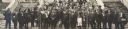
| Date: | 10 1914 |
|---|---|
| Description: | Fourth Annual Conference of American Indians taken in front of Lathrop Hall, University of Wisconsin-Madison campus. Included are: Mr. (William) Kershaw (M... |
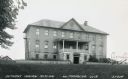
| Date: | 1935 |
|---|---|
| Description: | Exterior view of the Bethany Indian Mission School. Caption reads: "Bethany Indian Mission, Wittenberg, Wis." |
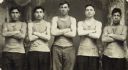
| Date: | 1889 |
|---|---|
| Description: | Three-quarter length studio portrait in front of a painted backdrop of five Hayward Indian School students, possibly a basketball team, from L to R: John C... |

| Date: | 1943 |
|---|---|
| Description: | A map that shows the lands for sale by the Tomahawk Land Company of Tomahawk, Wisconsin, in the counties of Langlade, Lincoln, Oneida, and Price. The map s... |

| Date: | 1880 |
|---|---|
| Description: | A hand-colored map of the Chippewa, Price, Taylor and the northern part of Clark counties, which shows the locations of farmhouses, schoolhouses, churches,... |

| Date: | 1980 |
|---|---|
| Description: | The general theme of this black and white map is "Discover and Enjoy Wisconsin." The front of the map depicts driving tours numbered 1 through 12; each to... |

| Date: | 1962 |
|---|---|
| Description: | This colored map represents "Tour #2" of a series of driving tours of the state published by the Sperry & Hutchinson Company, in order to "help you enjoy W... |

| Date: | 1962 |
|---|---|
| Description: | This colored map represents "Tour #1" of a series of driving tours of the state published by the Sperry & Hutchinson Company, in order to "help you enjoy W... |
If you didn't find the material you searched for, our Library Reference Staff can help.
Call our reference desk at 608-264-6535 or email us at: