 Filter: Categories of Wisconsin Historical Images
Filter: Subject of Wisconsin
Filter: Subject of architecture
Filter: Subject of land use
Filter: Categories of Wisconsin Historical Images
Filter: Subject of Wisconsin
Filter: Subject of architecture
Filter: Subject of land use
| Date: | |
|---|---|
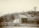
| Description: | View of large platform mound with small barn in the foreground. The numbers 1, 2, and 3 are written on the photograph in ink. |
| Date: | 1920 |
|---|---|
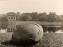
| Description: | In recognition of the loyalty and patronage of the Winnebago Indians. |

| Date: | |
|---|---|
| Description: | Wisconsin Memorial Hospital with a key to buildings in the upper left. Indian mounds are marked on the site. Arthur Peabody was the state architect for th... |
| Date: | |
|---|---|
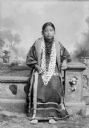
| Description: | Full-length studio portrait of a Ho-Chunk woman. She is sitting on a prop stone wall and is wearing a dress with earrings and long strands of beads. She is... |
| Date: | 1958 |
|---|---|
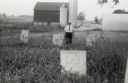
| Description: | Local historian William F. Wolf visiting the Native American cemetery. In the background is a barn and a silo and other farm buildings. |

| Date: | 1927 |
|---|---|
| Description: | Blueprint-style map of Frost Woods on the shore of Lake Monona. The map indicates the locations of Indian mounds, an Indian camp, and various plants. There... |

| Date: | 1943 |
|---|---|
| Description: | A map that shows the lands for sale by the Tomahawk Land Company of Tomahawk, Wisconsin, in the counties of Langlade, Lincoln, Oneida, and Price. The map s... |
If you didn't find the material you searched for, our Library Reference Staff can help.
Call our reference desk at 608-264-6535 or email us at: