 Filter: Categories of Wisconsin Historical Images
Filter: Subject of Wisconsin
Filter: Subject of architecture
Filter: Subject of cities and towns
Filter: Categories of Wisconsin Historical Images
Filter: Subject of Wisconsin
Filter: Subject of architecture
Filter: Subject of cities and towns
| Date: | |
|---|---|
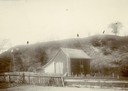
| Description: | View of large platform mound with small barn in the foreground. The numbers 1, 2, and 3 are written on the photograph in ink. |
| Date: | 1920 |
|---|---|
| Description: | In recognition of the loyalty and patronage of the Winnebago Indians. |

| Date: | |
|---|---|
| Description: | View of two small Native American children standing on the city scale. Across the street is a horse-drawn wagon near commercial buildings. |

| Date: | |
|---|---|
| Description: | Wisconsin Memorial Hospital with a key to buildings in the upper left. Indian mounds are marked on the site. Arthur Peabody was the state architect for th... |

| Date: | |
|---|---|
| Description: | View down wooden sidewalk towards a Ho-Chunk man smoking a cigar and wearing a duck bone breast plate and fur pants on the left, and a European American ma... |

| Date: | 1927 |
|---|---|
| Description: | Blueprint-style map of Frost Woods on the shore of Lake Monona. The map indicates the locations of Indian mounds, an Indian camp, and various plants. There... |

| Date: | 1880 |
|---|---|
| Description: | A hand-colored map of the Chippewa, Price, Taylor and the northern part of Clark counties, which shows the locations of farmhouses, schoolhouses, churches,... |
If you didn't find the material you searched for, our Library Reference Staff can help.
Call our reference desk at 608-264-6535 or email us at: