Filter: Categories of Wisconsin Historical Images
Filter: Subject of Wisconsin
Filter: Subject of agriculture
Filter: Categories of Wisconsin Historical Images
Filter: Subject of Wisconsin
Filter: Subject of agriculture
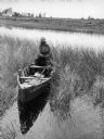
| Date: | 1907 |
|---|---|
| Description: | A Chippewa woman parching wild rice in Lac Vieux Desert. Lac Vieux Desert is a 4200 acre Michigan-Wisconsin boundary water in Vilas County. |
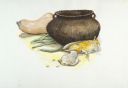
| Date: | 1997 |
|---|---|
| Description: | Oneota pottery and shell spoon with assorted vegetables, including corn, beans, and a gourd. |
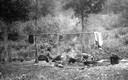
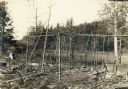
| Date: | 1912 |
|---|---|
| Description: | Vilas County, Ricing camp, Rice Creek. Lac Du Flambeau area. |
| Date: | 1912 |
|---|---|
| Description: | Vilas County, Ricing camp, Rice Creek. Lac Du Flambeau area. |
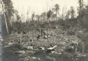
| Date: | 1912 |
|---|---|
| Description: | Vilas County, Ricing camp, Rice Creek. Lac Du Flambeau area. |

| Date: | 1930 |
|---|---|
| Description: | A Native American woman is sitting on the ground preparing corn for drying. A man, with arms akimbo, is standing nearby, observing. Husked corn is piled on... |
| Date: | 1941 |
|---|---|
| Description: | Joe Stoddard of the Chippewa tribe harvesting wild rice on the Bad River Indian Reservation. |

| Date: | 1838 |
|---|---|
| Description: | Territorial seal of Wisconsin. There is a farmer in the foreground plowing behind horses, a Native American apparently heading west, a river steamboat and ... |
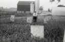
| Date: | 1958 |
|---|---|
| Description: | Local historian William F. Wolf visiting the Native American cemetery. In the background is a barn and a silo and other farm buildings. |

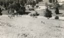
| Date: | 1927 |
|---|---|
| Description: | Three men and two women sit on top of a mound near Trade Lake. |

| Date: | 1937 |
|---|---|
| Description: | Pictorial map showing historical events and locations within the state of Wisconsin, as well as waterways and counties. Original caption on the bottom marg... |

| Date: | 1925 |
|---|---|
| Description: | This map shows trails, mounds, villages, corn fields, and contemporary civil townships; some villages and features include both Indian and English place na... |

| Date: | 1925 |
|---|---|
| Description: | An unidentified Native American man posing while sitting on a corn planter pulled by a team of horses. |
| Date: | 1925 |
|---|---|
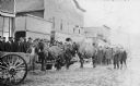
| Description: | View across unpaved road towards a Native American man wearing a plaid overcoat with two work horses. A crowd of men are watching from the elevated wooden ... |
| Date: | 1920 |
|---|---|
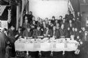
| Description: | A group of Native American men, women and children are posing around a table piled with ears of corn in front of a stage in an auditorium. Several of the m... |

| Date: | 1925 |
|---|---|
| Description: | Elevated view of a Native American man holding the lead of a horse as it is evaluated by another man, possibly Joseph Wojta, who is wearing a hat and long ... |

| Date: | 1930 |
|---|---|
| Description: | View across muddy ground towards a man holding a dairy cow by the halter, and on the left a boy holding the lead of a heifer. They are standing in front of... |

| Date: | 1920 |
|---|---|
| Description: | A handwritten sign identifies the "Shing-Wak Stock Farm, John B. Breselle (?) Prop., Dealer in Draft Horses." It also advertises "Green Mountain Seed Potat... |

| Date: | |
|---|---|
| Description: | Roger Little Eagle (Tallmadge) standing in a field holding a horse by the bridle. |
If you didn't find the material you searched for, our Library Reference Staff can help.
Call our reference desk at 608-264-6535 or email us at: