 Filter: Categories of Wisconsin Historical Images
Filter: Subject of Wisconsin
Filter: Creator Name of Unknown
Filter: County of Columbia
Filter: Categories of Wisconsin Historical Images
Filter: Subject of Wisconsin
Filter: Creator Name of Unknown
Filter: County of Columbia
| Date: | |
|---|---|
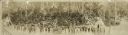
| Description: | Panoramic view of a large group of Native Americans posed in front of Stand Rock between two tipis. |

| Date: | 1800 |
|---|---|
| Description: | This map is pencil on tracing paper and shows marshes, the Wisconsin River, Indian trails, and Indian boundary line. The upper left corner reads: "Let sect... |

| Date: | |
|---|---|
| Description: | A night view of automobiles in the parking lot at the Stand Rock Amphitheater, where the Stand Rock Indian Ceremonial is performed. |

| Date: | 1900 |
|---|---|
| Description: | This manuscript map shows outline of Fort Winnebago reserve land, Fort Winnebago, claim of A. Grignon, and Indian boundaries. The Fox River and Swan Lake a... |
If you didn't find the material you searched for, our Library Reference Staff can help.
Call our reference desk at 608-264-6535 or email us at: