 Filter: Categories of Wisconsin Historical Images
Filter: Subject of Wisconsin
Filter: Type of Map or Atlas
Filter: Categories of Wisconsin Historical Images
Filter: Subject of Wisconsin
Filter: Type of Map or Atlas

| Date: | 1865 |
|---|---|
| Description: | This map of the entire state of Wisconsin depicts the township survey grid and identifies counties, named towns, cities and villages, rivers, lakes, railro... |

| Date: | 1867 |
|---|---|
| Description: | A hand-colored map of Wisconsin showing the state’s township grid, lakes, rivers, railroads, as well as the locations of towns, counties and the reservatio... |

| Date: | 1871 |
|---|---|
| Description: | This map of Wisconsin and surrounding states depicts the township survey grid and identifies counties, named towns, cities and villages, rivers, lakes, rai... |

| Date: | 1871 |
|---|---|
| Description: | This map of Wisconsin and surrounding states depicts the township survey grid and identifies counties, named towns, cities and villages, rivers, lakes, rai... |

| Date: | 1875 |
|---|---|
| Description: | This hand-colored map of Wisconsin and the western portion of Michigan's Upper Peninsula depicts the township survey grid and identifies counties, named to... |

| Date: | 1878 |
|---|---|
| Description: | A hand-colored, cloth mounted, sectional map of Wisconsin and the western portion of Michigan’s Upper Peninsula, showing the township grid, railroads, town... |

| Date: | 1880 |
|---|---|
| Description: | A hand-colored, sectional map of Wisconsin showing the township grid, railroads, counties, towns, cities, villages, and the Menomonee, Oneida, Flambeau, an... |

| Date: | 1882 |
|---|---|
| Description: | A hand-colored, sectional map of Wisconsin showing the township grid, completed and proposed railroads, counties, towns, cities, villages. The map also inc... |
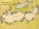
| Date: | |
|---|---|
| Description: | A color, pictorial map that shows sites related to Native American villages, sites, cemeteries in the area around the lakes Geneva and Como in Walworth Cou... |

| Date: | 1922 |
|---|---|
| Description: | A map of Iron County, Wisconsin, shows sections and the towns of Upson, Hurley, Hamilton, Saxon, and Mercer, lakes and streams, villages, railroads, roads ... |

| Date: | 1935 |
|---|---|
| Description: | Two hand-colored maps of the area comprising the town of Millston (Plats of Townships 20 and 21 north, range 2 west), Jackson County, Wisconsin, showing 40... |

| Date: | 1941 |
|---|---|
| Description: | A pictorial map of Lake Mendota that shows Indian sites and legends associated with the Lake and its surrounding area. Some of those mentioned on the map i... |

| Date: | 1941 |
|---|---|
| Description: | This pictorial map shows sites related to Indian legends, mounds, and trails in the Chain O' Lakes region in southwestern Waupaca County, Wisconsin. |

| Date: | 1850 |
|---|---|
| Description: | Map showing Indian mounds and graves as well as ground cover types at Township 8, Range 22. There is an inset diagram of an effigy mound labeled "The Cross... |

| Date: | |
|---|---|
| Description: | Map showing Indian mounds in Milwaukee's Second Ward from a sketch made by Increase Lapham in 1836. Streets shown on the map include 6th Street, 5th Street... |

| Date: | 1800 |
|---|---|
| Description: | This map is pencil on tracing paper and shows marshes, the Wisconsin River, Indian trails, and Indian boundary line. The upper left corner reads: "Let sect... |

| Date: | 1924 |
|---|---|
| Description: | This pictorial map focuses on the Madison Isthmus, Lake Mendota, Lake Monona, Lake Wingra, and shows points of historical interest, buildings, parks, and I... |

| Date: | 1941 |
|---|---|
| Description: | This map is ink and watercolor on cardboard and shows Native American legends and villages pictorially. Trails are also shown. |

| Date: | 1945 |
|---|---|
| Description: | This maps shows roads, railroads, parks, recreational areas, Lake Wingra, Lake Monona, and part of Lake Mendota. The map includes pictorial images that dep... |

| Date: | 1838 |
|---|---|
| Description: | This map is a development plat that shows street names, numbered blocks and lots, and small farm lot owners. Included on the right of the map is a large am... |
If you didn't find the material you searched for, our Library Reference Staff can help.
Call our reference desk at 608-264-6535 or email us at: