 Filter: Categories of Wisconsin Historical Images
Filter: Subject of Winnebago Indians
Filter: Subject of menominee indians
Filter: Categories of Wisconsin Historical Images
Filter: Subject of Winnebago Indians
Filter: Subject of menominee indians
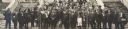
| Date: | 10 1914 |
|---|---|
| Description: | Fourth Annual Conference of American Indians taken in front of Lathrop Hall, University of Wisconsin-Madison campus. Included are: Mr. (William) Kershaw (M... |

| Date: | 1857 |
|---|---|
| Description: | A map of the state of Wisconsin and the southeastern portion of the Territory of Minnesota, showing the Wisconsin reservations of the Oneida, Menominee, St... |

| Date: | 1860 |
|---|---|
| Description: | A survey map of Wisconsin, southeastern Minnesota, and northern Iowa, showing the status of surveys, rivers, and lakes. The map also shows the locations of... |

| Date: | 1979 |
|---|---|
| Description: | A map of Southern Wisconsin and northern Illinois showing the areas inhabited by the Ho-Chuck, formerly known as the Winnebago. Some of the location names ... |

| Date: | 1930 |
|---|---|
| Description: | This map shows rivers, lakes, trails, Indian villages, distances, and boundaries of tracts ceded by the Munnomonee, Winnebaygoes, and New York Indians Trib... |
If you didn't find the material you searched for, our Library Reference Staff can help.
Call our reference desk at 608-264-6535 or email us at: