 Filter: Categories of Wisconsin Historical Images
Filter: Subject of Winnebago Indians
Filter: Subject of dwellings
Filter: Categories of Wisconsin Historical Images
Filter: Subject of Winnebago Indians
Filter: Subject of dwellings

| Date: | 1941 |
|---|---|
| Description: | Hand-drawn, watercolor and ink, map of Lake Mendota. Locations and many small figures appear around the shore with explanations referring to Indian legends... |
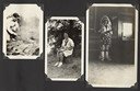
| Date: | |
|---|---|
| Description: | Page from Joy Camps photo album displaying three photographs. In one photograph Barbara Ellen Joy, camp owner and co-director, cooks over a large grill are... |

| Date: | |
|---|---|
| Description: | A Native American Ho-Chunk woman stands holding a baby outside a wigwam. Another child stands just in front of the woman, looking off to the right. The pho... |
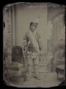
| Date: | |
|---|---|
| Description: | Full-length studio portrait in front of a painted background of Little Soldier. He is standing next to a chair and holding a firearm. Hand-coloring on chee... |

| Date: | 1930 |
|---|---|
| Description: | This map shows rivers, lakes, trails, Indian villages, distances, and boundaries of tracts ceded by the Munnomonee, Winnebaygoes, and New York Indians Trib... |

| Date: | |
|---|---|
| Description: | Elevated view of a large group of men and women in ceremonial clothing, dancing the Green Corn Dance of the Winnebagos. A sign in the background reads: "Si... |

| Date: | |
|---|---|
| Description: | A view of the curved garden beds on the west shore of Lake Winnebago, two miles north of Winnebago, Wisconsin. |
If you didn't find the material you searched for, our Library Reference Staff can help.
Call our reference desk at 608-264-6535 or email us at: