 Filter: Categories of Wisconsin Historical Images
Filter: Subject of Windmills
Filter: Subject of rivers
Filter: Categories of Wisconsin Historical Images
Filter: Subject of Windmills
Filter: Subject of rivers

| Date: | 1885 |
|---|---|
| Description: | Bird's-eye map of Waupun on the Rock River. There is an inset at top center of "Althouse, Wheeler & Co., Windmills and Pumps." |

| Date: | 1882 |
|---|---|
| Description: | This map of Cedarburg is a bird's-eye map with an inset of Cedarburg Brewery. Relief is shown pictorially and the map includes an index to buildings. |
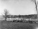
| Date: | |
|---|---|
| Description: | View across field towards the railroad bridge, seen with the construction almost completed. A man is standing in the middle of the bridge, and two or three... |
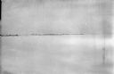
| Date: | 1918 |
|---|---|
| Description: | View over frozen expanse, probably the Pinega River, of the Pinega settlement in northern Russia. Buildings and a windmill are along the shoreline. |
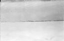
| Date: | 1918 |
|---|---|
| Description: | View over frozen expanse, probably the Pinega River, of the Pinega settlement in northern Russia. There are many wooden structures and dwellings along a lo... |

| Date: | 1907 |
|---|---|
| Description: | Elevated view from hill towards the Fox River, with a farm in the foreground. The farm has a windmill with a sign on it that reads: "Kilbourn Steel Mill," ... |
If you didn't find the material you searched for, our Library Reference Staff can help.
Call our reference desk at 608-264-6535 or email us at: