Filter: Categories of Wisconsin Historical Images
Filter: Subject of Windmills
Filter: Subject of intellectual life
Filter: Subject of human settlements
Filter: Categories of Wisconsin Historical Images
Filter: Subject of Windmills
Filter: Subject of intellectual life
Filter: Subject of human settlements

| Date: | 1885 |
|---|---|
| Description: | Bird's-eye map of Waupun on the Rock River. There is an inset at top center of "Althouse, Wheeler & Co., Windmills and Pumps." |

| Date: | 1882 |
|---|---|
| Description: | This map of Cedarburg is a bird's-eye map with an inset of Cedarburg Brewery. Relief is shown pictorially and the map includes an index to buildings. |

| Date: | 04 12 1907 |
|---|---|
| Description: | Photographic postcard of an aerial view of town looking North. The Mississippi River is on the left. |

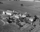
| Date: | 1908 |
|---|---|
| Description: | Elevated photographic postcard view of town showing homes and businesses. A windmill is in the foreground. The school is on the far edge of town on the lef... |
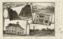
| Date: | 1905 |
|---|---|
| Description: | Photographic postcard of a collage of 5 views of Brandon including; Washington St., Public Square, Times Office, High School, and Depot & Park. |
If you didn't find the material you searched for, our Library Reference Staff can help.
Call our reference desk at 608-264-6535 or email us at: