 Filter: Categories of Wisconsin Historical Images
Filter: Subject of Wells
Filter: Type of Map or Atlas
Filter: Categories of Wisconsin Historical Images
Filter: Subject of Wells
Filter: Type of Map or Atlas

| Date: | 1966 |
|---|---|
| Description: | The map shows streets, wells, school land, parks, cemeteries, railroads, and the Delbrook Golf Course. The bottom of the map reads: "January 11, 1962 May 2... |

| Date: | 1960 |
|---|---|
| Description: | This blue line print map shows pipes, valves, well site, and elevation tank, as well as lot and block numbers and dimensions. The map includes inset of con... |
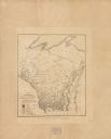
| Date: | 1905 |
|---|---|
| Description: | This map shows the location of artesian wells. Includes a legend depicting various levels of ground water, locations of flowing and non-flowing wells. Incl... |
If you didn't find the material you searched for, our Library Reference Staff can help.
Call our reference desk at 608-264-6535 or email us at: