Filter: Categories of Wisconsin Historical Images
Filter: Subject of Waterfalls
Filter: Subject of rivers
Filter: Categories of Wisconsin Historical Images
Filter: Subject of Waterfalls
Filter: Subject of rivers

| Date: | |
|---|---|
| Description: | A map of the western Upper Peninsula of Michigan and Wisconsin north of Lake Winnebago and east of Lake Pepin and the mouth of the Saint Louis River on Lak... |

| Date: | 01 09 1849 |
|---|---|
| Description: | Shows county line boundaries, rivers, and falls. Includes explanation of township and county divisions. Pen and pencil on paper. Title supplied by cataloge... |
| Date: | |
|---|---|
| Description: | We've at least been able to conserve something if it's only the idea of conserving for conservation's sake But the community interests ought to come fir... |
| Date: | 1931 |
|---|---|
| Description: | A group of people stand on a ledge overlooking Copper Falls. |
| Date: | |
|---|---|
| Description: | We tend to forget that at the time of the destruction of the forests, an emergency situation existed. The need for lumber for the building up of the... |
| Date: | |
|---|---|
| Description: | Elevated view of Copper Falls on the Bad River. Four people, one man and three women, are posing on rocks at the top of the falls. Surrounding burned-over ... |

| Date: | |
|---|---|
| Description: | View through trees of Copper Falls, on the Bad River. |

| Date: | 1698 |
|---|---|
| Description: | An illustration of two men looking out at Niagara Falls. The Niagara Falls in Jean Louis Hennepin’s A new discovery of a vast country in America (London: M... |
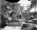
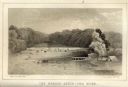
| Date: | |
|---|---|
| Description: | View from shoreline towards a man and woman posed standing on a footbridge over a small waterfall. On the right a woman sits with a child in her lap on the... |
| Date: | 1863 |
|---|---|
| Description: | Carte-de-visite view of the Falls of Saint Anthony and logs caught on rocks in the falls. |

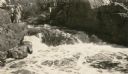
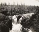
| Date: | 1913 |
|---|---|
| Description: | Elevated view of the Eau Claire River rushing over large rocky formations. A bridge crosses over the river on the left. Large tree trunks have been stacked... |
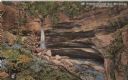
| Date: | 1914 |
|---|---|
| Description: | Postcard for Marquette Park in Grant County, number 4706 in a series by E.A. Bishop of Racine. The caption on the back of the postcard reads: "The pictures... |
| Date: | 1856 |
|---|---|
| Description: | Lithographic view of the Grande Chute Falls on the Fox River. There is a tent on the shore on the right. |

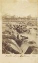
| Date: | 1910 |
|---|---|
| Description: | Photographic postcard view of High Falls. Caption reads: "High Falls, Crivitz, Wis." |

| Date: | 1910 |
|---|---|
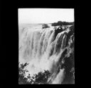
| Description: | Elevated view looking over the Zambesi River towards Victoria Falls, South Africa. |

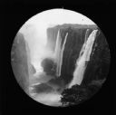
| Date: | 1910 |
|---|---|
| Description: | View of Victoria Falls, South Africa, looking East. |
| Date: | 1910 |
|---|---|
| Description: | Elevated view of Victoria Falls, South Africa, looking down at the Zambezi River. |

| Date: | 1910 |
|---|---|
| Description: | Doctor Thorne was one of the members of Carrie's travel party. He is pictured here, in front of Victoria Falls on Livingstone Island. |

| Date: | 1910 |
|---|---|
| Description: | Black and white photographic postcard view of a waterfall on the Little Niagara River. A footbridge extends over the waterfall. |
If you didn't find the material you searched for, our Library Reference Staff can help.
Call our reference desk at 608-264-6535 or email us at: