Filter: Categories of Wisconsin Historical Images
Filter: Subject of Water-power
Filter: Subject of water
Filter: Categories of Wisconsin Historical Images
Filter: Subject of Water-power
Filter: Subject of water
| Date: | 1873 |
|---|---|
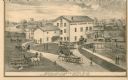
| Description: | A print depicts activity around the three-story, wood frame Geneva Flouring Mills. Horse-drawn wagons, pedestrians, and a boy rolling a hoop create a busy ... |

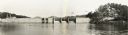
| Date: | |
|---|---|
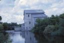
| Description: | View across river or stream towards a pump house along a stony shoreline. A large pipe supported on trestles is attached to the right side of the building.... |

| Date: | 1891 |
|---|---|
| Description: | This blueprint manuscript map shows land owned by Kaukauna Water Power Co., Green Bay & Mississippi Canal Co., A.W. Patten, N.M. Edwards, and M.J. Meade. P... |

| Date: | |
|---|---|
| Description: | View across water towards a water wheel, probably used for irrigation, near a shoreline. Ducks are swimming in the water near the tall grass is growing on ... |

| Date: | 1914 |
|---|---|
| Description: | A man is sitting on a water wheel used for irrigation. |
| Date: | 05 06 1973 |
|---|---|
| Description: | Black ink line drawing of a fisherman on the bank of Big Spring Creek near a power house and dam. Puffy clouds fill the sky in the background and thick veg... |

| Date: | |
|---|---|
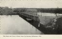
| Description: | View across water towards the Pumping Station on the riverfront. Central Jefferson is in the background. There are billboards on the right, with one that r... |
| Date: | 1924 |
|---|---|
| Description: | Illustration based on an aerial photograph of a powerhouse and dam on the Wisconsin River. A railroad bridge is upriver. The city of Kilbourn (now Wisconsi... |
| Date: | |
|---|---|
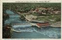
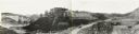
| Description: | Slightly elevated view of the dam and power house from across the Wisconsin River. Caption reads: "Dam and Power House from Up Stream, Kilbourne [sic], Wis... |
| Date: | 1950 |
|---|---|
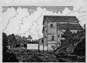
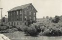
| Description: | View across water towards the Historic Monticello Woolen Mill. There are many windows on the mill building, and some of them are open. Other buildings are ... |
| Date: | 06 1962 |
|---|---|
| Description: | Landscape photograph by Sid Boyum of a fisherman on the bank of Big Spring Creek near a power house and dam. The fisherman to the right blends into the bui... |
| Date: | 1935 |
|---|---|
| Description: | An elevated, panoramic view of the construction of the Norris Dam. Portions of the image are labeled. |
| Date: | 05 23 1936 |
|---|---|
| Description: | Elevated, panoramic view across water towards the Norris Dam. Portions of the image are labeled. |

| Date: | 1937 |
|---|---|
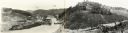
| Description: | Elevated, panoramic view of the Norris Dam from the west side of the Clinch River. |

| Date: | 1935 |
|---|---|
| Description: | Panoramic view of the construction of the Norris Dam, looking upstream. On the left the text reads: "West Bank," and on the right it reads: "East Bank." |

| Date: | 12 13 1938 |
|---|---|
| Description: | Elevated, panoramic view of the Wheeler Dam from the south side of the Tennessee River. |

| Date: | 08 01 1936 |
|---|---|
| Description: | Elevated, panoramic view of the Pickwick Dam under construction. |

| Date: | 03 24 1937 |
|---|---|
| Description: | Elevated, panoramic view of the construction of the Pickwick Dam power house and spillway. |
If you didn't find the material you searched for, our Library Reference Staff can help.
Call our reference desk at 608-264-6535 or email us at: