Filter: Categories of Wisconsin Historical Images
Filter: Subject of Water-power
Filter: Subject of architecture
Filter: Subject of rivers
Filter: Categories of Wisconsin Historical Images
Filter: Subject of Water-power
Filter: Subject of architecture
Filter: Subject of rivers
| Date: | 1905 |
|---|---|
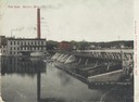
| Description: | View of the dam and power plant over the river, with smokestacks in the background. Caption reads: "The Dam, Beloit, Wis." |
| Date: | 1913 |
|---|---|
| Description: | Dam and hydroelectric power house, with a billowing smokestack and a crane in the background. |

| Date: | |
|---|---|
| Description: | View of the roiling lower falls on Spokane River with two bridges, and a large stone building with a sign that reads: "Washington Water Power Co." is above... |
| Date: | |
|---|---|
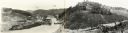
| Description: | Elevated view of the mill, dam, and railroad tracks, and forests surrounding the area. The lumber mill itself, with main building complex and smokestack is... |

| Date: | |
|---|---|
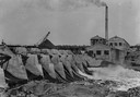
| Description: | View of a dam, with industrial buildings on the opposite shoreline. A factory building has a sign that reads: "Home of Old Hampshire Bond," and "Hampshire ... |
| Date: | |
|---|---|
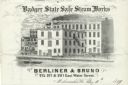
| Description: | Letterhead of the Berliner & Bruno's Badger State Safe Steam Works of Milwaukee, Wisconsin, with a three-quarter view of the steam works and depot, people ... |

| Date: | |
|---|---|
| Description: | Outdoor view looking down at men working on a high brick foundation on the river, with a railroad bridge in the background. Identified as the laying of the... |

| Date: | 1910 |
|---|---|
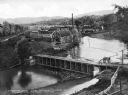
| Description: | Outdoor view from shoreline towards a powerhouse on the river, with town buildings in the background on the opposite shoreline. Identified as the second po... |

| Date: | 1910 |
|---|---|
| Description: | Outdoor view looking down a hill towards a powerhouse on the river, with town buildings on a hill in the background. Identified as the second powerhouse th... |

| Date: | 1910 |
|---|---|
| Description: | Outdoor view looking down at a powerhouse, with town buildings in the background and men fishing along the shoreline. Identified as the third powerhouse bu... |

| Date: | 1905 |
|---|---|
| Description: | View across water towards a powerhouse among very high water on the Black River. Identified as the second power house with high water in 1905. |

| Date: | |
|---|---|
| Description: | View across river or stream towards a pump house along a stony shoreline. A large pipe supported on trestles is attached to the right side of the building.... |

| Date: | 1891 |
|---|---|
| Description: | This blueprint manuscript map shows land owned by Kaukauna Water Power Co., Green Bay & Mississippi Canal Co., A.W. Patten, N.M. Edwards, and M.J. Meade. P... |

| Date: | |
|---|---|
| Description: | View across water towards the Pumping Station on the riverfront. Central Jefferson is in the background. There are billboards on the right, with one that r... |
| Date: | 1935 |
|---|---|
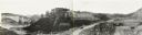
| Description: | An elevated, panoramic view of the construction of the Norris Dam. Portions of the image are labeled. |
| Date: | 05 23 1936 |
|---|---|
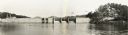
| Description: | Elevated, panoramic view across water towards the Norris Dam. Portions of the image are labeled. |

| Date: | 1937 |
|---|---|
| Description: | Elevated, panoramic view of the Norris Dam from the west side of the Clinch River. |
| Date: | 1935 |
|---|---|
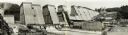
| Description: | Panoramic view of the construction of the Norris Dam, looking upstream. On the left the text reads: "West Bank," and on the right it reads: "East Bank." |
If you didn't find the material you searched for, our Library Reference Staff can help.
Call our reference desk at 608-264-6535 or email us at: