 Filter: Categories of Wisconsin Historical Images
Filter: Subject of Water towers
Filter: Subject of intellectual life
Filter: Subject of lakes
Filter: Categories of Wisconsin Historical Images
Filter: Subject of Water towers
Filter: Subject of intellectual life
Filter: Subject of lakes

| Date: | 1957 |
|---|---|
| Description: | Aerial view of town including water tower, city streets, houses, and other buildings. |
| Date: | |
|---|---|
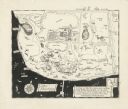
| Description: | A pen drawing, in the style of a birds-eye map, of Frank and Delia King's estate Folly Farm in Kissimee, Florida. |

| Date: | |
|---|---|
| Description: | Aerial view of a developed strip of land on Barnegat Bay showing the Atlantic ocean, houses, lakes, railroad tracks, a marina and a jetty in the distance. |

| Date: | 1900 |
|---|---|
| Description: | Perspective drawing of the buildings at the Hayward Indian School. There is a man in a boat in the right foreground and an empty boat in the left foregroun... |

| Date: | |
|---|---|
| Description: | Aerial view looking southwest towards the Wisconsin State Capitol on the Capitol Square. Lake Wingra and Lake Monona are in the background. |
| Date: | |
|---|---|
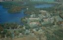
| Description: | Aerial view of the Wisconsin Veterans' Home campus beside Chain O' Lakes and the village of King. Text on reverse reads: "Founded in 1887 by The Grand A... |

| Date: | 1923 |
|---|---|
| Description: | Aerial view of Capitol Square and surrounding area from East Washington Avenue. The old water tower in the center. Lake Monona is on the left; Lake Mendota... |
If you didn't find the material you searched for, our Library Reference Staff can help.
Call our reference desk at 608-264-6535 or email us at: