 Filter: Categories of Wisconsin Historical Images
Filter: Subject of Water
Filter: Categories of Wisconsin Historical Images
Filter: Subject of Water

| Date: | 1821 |
|---|---|
| Description: | Engraving of the Pictured Rocks shoreline viewed from Lake Superior. |

| Date: | 1821 |
|---|---|
| Description: | Engraving depicting the Schoolcraft expedition crossing the Ontonagon River to investigate a copper boulder. |

| Date: | 1850 |
|---|---|
| Description: | Travelers in a rowing canoe on Lake Superior. |

| Date: | 1850 |
|---|---|
| Description: | Elevated view of the Lake Superior shoreline, with terraces leading to the beach. A canoe is on the shoreline. |

| Date: | 1850 |
|---|---|
| Description: | Pastoral scene depicting a small bay on the Island of St. Ignace in Lake Superior with canoes on the rocky beach, two men conversing on a blanket in the fo... |

| Date: | 1850 |
|---|---|
| Description: | Pic Island on the north shore of Lake Superior. |
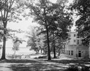
| Date: | 1930 |
|---|---|
| Description: | View of the Memorial Union Terrace on Lake Mendota. |

| Date: | 1851 |
|---|---|
| Description: | Plat map of the Town of Madison (Township 7N, Range 9E), from Volume 4, Federal Survey Plat Books. |
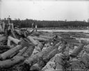
| Date: | 1903 |
|---|---|
| Description: | Three barefoot boys stand on a pile of logs in the foreground looking across the river at a group of men working to free a log jam in the Big Eddy on the C... |
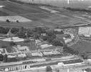
| Date: | 1958 |
|---|---|
| Description: | Aerial photograph showing the J.S. Timlin Lumber Company, 2702 University Avenue, as well as Doctors Park, the Veterans Hospital, and the First Unitarian S... |

| Date: | 1873 |
|---|---|
| Description: | Map of the township of Windsor, from the "Atlas of Dane County." |
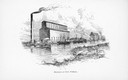
| Date: | |
|---|---|
| Description: | Illustration of exterior view of elevators at Fort William. |

| Date: | 1848 |
|---|---|
| Description: | In 1849, northern Wisconsin was composed of huge sectional regions such as Chippewa, Portage, Brown and Crawford, whereas southern Wisconsin was constitute... |

| Date: | 1873 |
|---|---|
| Description: | Newspaper reproduction of an etching of the Milwaukee River. |

| Date: | 1964 |
|---|---|
| Description: | Aerial view of the Milwaukee County Zoo grounds nearing its completion. |
| Date: | 05 15 1954 |
|---|---|
| Description: | Zookeepers releasing rhesus monkeys to the island that serves as their summer home at the Washington park zoo (later replaced by the Milwaukee County Zoo). |
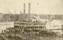
| Date: | |
|---|---|
| Description: | The steamboat Canada at dock; cargo on lower deck, passengers on upper deck, and crowd waiting on the dock. The Canada was built in 1858, dis... |
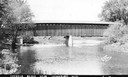
| Date: | 1940 |
|---|---|
| Description: | Exterior view of the last covered bridge in Wisconsin. Caption reads: "Covered Bridge Near Cedarburg, Wis." |
If you didn't find the material you searched for, our Library Reference Staff can help.
Call our reference desk at 608-264-6535 or email us at:

