 Filter: Categories of Wisconsin Historical Images
Filter: Subject of Water
Filter: Year of 1800-1899
Filter: Categories of Wisconsin Historical Images
Filter: Subject of Water
Filter: Year of 1800-1899

| Date: | 1852 |
|---|---|
| Description: | An illustration of a storm encountered by a delegation of Indians on their way to Washington, D.C. |
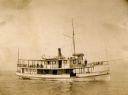
| Date: | 1895 |
|---|---|
| Description: | Captain F.A. Bishoff and engineer Dan Cook on board the ferry "Plowboy." |

| Date: | 1884 |
|---|---|
| Description: | A sign for Fauerbach's Brewery depicting a young woman and the brewery. |
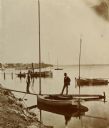
| Date: | 1890 |
|---|---|
| Description: | Two men pose on a boat docked at the Askew Steamboat Landing on Lake Monona off South Carroll Street. The old Governor Harvey residence is in the backgroun... |
| Date: | 1897 |
|---|---|
| Description: | A view of Lone Rock from below, with a canoe on the left-hand side. |

| Date: | 1885 |
|---|---|
| Description: | Elevated view of the "Dell Queen" entering the Narrows via Devil's Elbow as Hattie and Nellie Bennett look on from an overlook on the shoreline. |

| Date: | 1871 |
|---|---|
| Description: | Advertising poster for the Dodge improved combined self raking reaper and mower featuring a color illustration of a well-dressed farmer on the machine pull... |
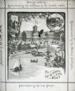
| Date: | 1883 |
|---|---|
| Description: | Tonyawatha Spring Hotel from a descriptive brochure. The hotel opened in 1879 and was destroyed by fire on July 31, 1895. |
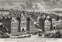
| Date: | 1887 |
|---|---|
| Description: | Engraving of an elevated view of Science Hall, Chemical Laboratory and Machine Shop on the University of Wisconsin-Madison campus. |
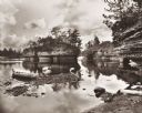
| Date: | 1875 |
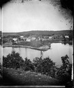
|---|---|
| Description: | A view of the village from a nearby bluff across a pond. Men, women and children, standing spaced apart, are posing in the field near the pond. |

| Date: | 1886 |
|---|---|
| Description: | Bird's-eye view of Ashland, on the shores of Lake Superior, with insets of The Apostle Islands Chequamagon Bay & Ashland, and Distances from Ashland. |

| Date: | 1856 |
|---|---|
| Description: | This map show the surveyed southern part of state and includes "profile of the Milwaukee and Mississippi Rail Road." Counties are shown in pink, green, blu... |

| Date: | 1880 |
|---|---|
| Description: | Bird's-eye view of Jefferson on the Rock River. |

| Date: | 1871 |
|---|---|
| Description: | Drawing of the Peshtigo Fire, showing people seeking refuge in the Peshtigo River. |

| Date: | 1842 |
|---|---|
| Description: | This hand-colored lithograph of the second Fort Howard, with Indians canoeing on the Fox River, shows the hospital built 1834-1835 outside the stockade on ... |

| Date: | 1886 |
|---|---|
| Description: | This map shows U.S. land offices, completed railroads, railroad land grant limits, lakes, rivers, and Indian reservations. Communities, lakes, and rivers a... |

| Date: | 06 1837 |
|---|---|
| Description: | Lithograph based on a painting by Mrs. E.E. Bailey showing the Peck cabin, the first house in Madison. In addition to the cabin, the lithograph includes a ... |

| Date: | 1898 |
|---|---|
| Description: | Old Mission Residence at La Pointe, Madeline Island. |

| Date: | 1821 |
|---|---|
| Description: | Indians of the North Red River area, probably in the vicinity of old Fort Douglas, now Winnipeg, Canada, spearing beaver. |
If you didn't find the material you searched for, our Library Reference Staff can help.
Call our reference desk at 608-264-6535 or email us at:
