Filter: Categories of Wisconsin Historical Images
Filter: Subject of Water
Filter: Year of 1800-1899
Filter: Categories of Wisconsin Historical Images
Filter: Subject of Water
Filter: Year of 1800-1899

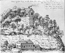
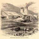
| Date: | 1847 |
|---|---|
| Description: | Engraving of the McCormick Reaper Works as it appeared in 1847. The factory was located on the north bank of the Chicago River, east of the Michigan Avenue... |
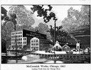
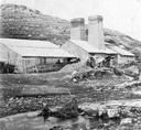
| Date: | 1867 |
|---|---|
| Description: | Engraving of the McCormick Reaper Works as it appeared in 1867. The factory was located on the north bank of the Chicago River, east of the Rush Street bri... |
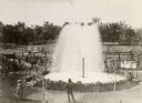
| Date: | 1880 |
|---|---|
| Description: | Elevated view of Artesian Well, located near the intersection of Wisconsin Street and South Minnesota Street (since renamed Wacouta). It was dubbed by some... |
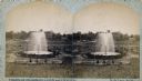
| Date: | 1880 |
|---|---|
| Description: | Stereograph of the Artesian Well near the intersection of Wisconsin and Minnesota (later renamed Wacouta) Streets. The following is printed on the back of ... |
| Date: | 05 1866 |
|---|---|
| Description: | Engraved exterior view of a smelting furnace with a small group of men with horses gathered in front. |
| Date: | 1850 |
|---|---|
| Description: | Blast furnace, also known as a Scotch hearth used in lead mining. |
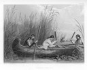
| Date: | 1884 |
|---|---|
| Description: | Three women in a canoe harvest wild rice. |

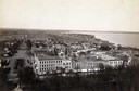
| Date: | 1876 |
|---|---|
| Description: | Bird's-eye view of Black Earth. |
| Date: | 1885 |
|---|---|
| Description: | South Pinckney Street between East Washington Avenue (left) and King Street (right). On the right is the Marquette neighborhood. The large structure at the... |

| Date: | 1867 |
|---|---|
| Description: | Birds-eye drawing of Appleton, Outagamie Co., depicting street names and street layout, houses, the Fox River, the court house, jail, school houses, Lawren... |
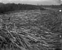
| Date: | 1895 |
|---|---|
| Description: | Logs move down the river, swirling with cross currents, resulting in a huge log jam. |
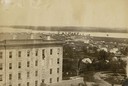
| Date: | 1861 |
|---|---|
| Description: | View of Madison from Main Hall, now Bascom Hall, on the University of Wisconsin-Madison campus. South Hall is in the foreground, with several residences an... |
| Date: | 1861 |
|---|---|
| Description: | View of Madison from Main Hall, now Bascom Hall, on the University of Wisconsin-Madison campus. South Hall is in the foreground with several residences an... |

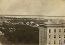
| Date: | 1861 |
|---|---|
| Description: | View of Madison from Main Hall, now Bascom Hall, on the University of Wisconsin-Madison campus looking up State Street toward the second Wisconsin State Ca... |
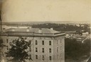
| Date: | 1861 |
|---|---|
| Description: | View of Madison from Main Hall, now Bascom Hall, on the University of Wisconsin-Madison campus. North Hall is in the foreground with several residences and... |
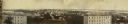
| Date: | 11 11 1861 |
|---|---|
| Description: | Panoramic view of Madison from Main Hall, now Bascom Hall, on the University of Wisconsin campus. North Hall and South Hall are in the foreground. Lake Men... |

| Date: | 1839 |
|---|---|
| Description: | This map shows the hydrology of Madison and its vicinity at the height of interest in a proposed Milwaukee and Rock River Canal. It was made by Thomas Jeff... |

| Date: | 1839 |
|---|---|
| Description: | A map of the Wiskonsin [sic] and Neenah or Fox Rivers. |

| Date: | 1832 |
|---|---|
| Description: | Hand-drawn map in two parts of the route of Governor J.D. Doty. Probably made by Doty in 1832 as a result of his travels with Alexander J. Center. |
If you didn't find the material you searched for, our Library Reference Staff can help.
Call our reference desk at 608-264-6535 or email us at: