 Filter: Categories of Wisconsin Historical Images
Filter: Subject of Water
Filter: Year of 1800-1899
Filter: Categories of Wisconsin Historical Images
Filter: Subject of Water
Filter: Year of 1800-1899
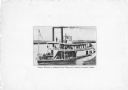
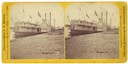
| Date: | 1882 |
|---|---|
| Description: | The sternwheel packet, Red Wing, at a landing on the upper Mississippi River between 1870 and 1882. There is a bridge behind the boat on the left. S... |
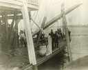
| Date: | 1895 |
|---|---|
| Description: | The sidewheel excursion, Saint Paul, after running aground near Muscatine. The spar is set and the line out. Dan Sauer, the carpenter, is holding th... |
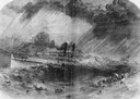
| Date: | 09 22 1860 |
|---|---|
| Description: | Sketch from the "New York Illustrated News" of the sinking of the sidewheel passenger, Lady Elgin. She was struck and sunk by the Augusta on ... |

| Date: | 1831 |
|---|---|
| Description: | Drawing of Fort Winnebago (near present-day Portage) that illustrated "Wau-Bun," Juliette Kinzie's memoir of her experiences on the early Wisconsin fronti... |
| Date: | 1870 |
|---|---|
| Description: | The sternwheel excursion, Minnieta, on the Chippewa River, Wisconsin, in the 1870's. |
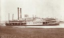
| Date: | 1870 |
|---|---|
| Description: | The sternwheel packet, Red Wing, at a landing on the upper Mississippi River between 1870 and 1882. The sign painted over the wheel reads: "Keokuk N... |
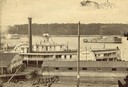
| Date: | 1863 |
|---|---|
| Description: | Elevated view of the steamboat Golden Era, which did service during the Civil War, docked near buildings. It was sold to Michael Purcell of New Orle... |

| Date: | 1861 |
|---|---|
| Description: | Drawn the first year of the Civil War, this colored 1861 map of Dane County shows its towns, cities and lakes. It includes insets of the wards of Madison a... |
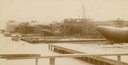
| Date: | 1892 |
|---|---|
| Description: | Text at bottom reads: Ship Yards — McDougall Whaleback. West Superior, Wis." Whaleback steamer in the shipyards of the American Steel Barge Company. |
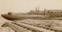
| Date: | 1892 |
|---|---|
| Description: | Text at bottom reads: Ship Yards — McDougall Whaleback. West Superior, Wis." Captain Alex McDougall's whaleback steamer in the shipyard of the American Ste... |
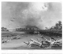
| Date: | 1832 |
|---|---|
| Description: | Steamboat navigating through sunken trees on the Missouri River. |
| Date: | 1832 |
|---|---|
| Description: | Engraving of Indians on horseback along river with Indian grave on hill in background. |
| Date: | 1832 |
|---|---|
| Description: | Travellers setting up camp along the Missouri River. |

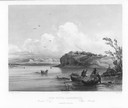
| Date: | 1832 |
|---|---|
| Description: | Black and white engraving showing landscape with Fort Pierre and Indian tipis along the Missouri River. |
| Date: | 1832 |
|---|---|
| Description: | Punka Indians encamped on the banks of the Missouri River and canoeing in river. |
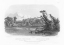
| Date: | 1832 |
|---|---|
| Description: | Mih-Tutta-Hangkusch, a Mandan village with boats on the river in foreground. |

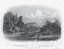
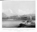
| Date: | 1832 |
|---|---|
| Description: | Junction of the Yellowstone River and the Missouri River. |

| Date: | 1891 |
|---|---|
| Description: | Bird's-eye map of Wausau, looking north with ninety-eight businesses, industries, churches, schools, and civic buildings identified in location key below i... |

| Date: | 1886 |
|---|---|
| Description: | Bird's-eye view of Bayfield, county seat of Bayfield County. On the lower left side is an inset for Bayfield and the Apostle Islands. |
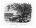
| Date: | 1832 |
|---|---|
| Description: | Camp of the Gros Ventres along the upper Missouri River, with white travelers passing by in a boat. |
If you didn't find the material you searched for, our Library Reference Staff can help.
Call our reference desk at 608-264-6535 or email us at: