 Filter: Categories of Wisconsin Historical Images
Filter: Subject of Water
Filter: Year of 1700-1799
Filter: Categories of Wisconsin Historical Images
Filter: Subject of Water
Filter: Year of 1700-1799

| Date: | 1744 |
|---|---|
| Description: | A map of a plan of 16,500 acres of land. |

| Date: | 1780 |
|---|---|
| Description: | Hand-drawn plan for the layout of the town of Clarksville, bordering Mayfield Creek and Liberty Creek. Fort Jefferson is shown between the townsite and the... |

| Date: | 1784 |
|---|---|
| Description: | Plate 41. Scene from Cook's Third Expedition, 1776-1779, while in Alaska. |
| Date: | 1784 |
|---|---|
| Description: | Plate 43. Scene from Cook's Third Expedition, 1776-1779, while in Alaska. |

| Date: | 1784 |
|---|---|
| Description: | Plate 45. Scene from Cook's Third Expedition, 1776-1779, while in Alaska. |

| Date: | 1784 |
|---|---|
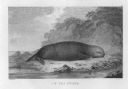
| Description: | Plate 50. Portrait from Cook's Third Expedition, 1776-1779, while in Alaska. |

| Date: | 1784 |
|---|---|
| Description: | Plate 57. Scene from Cook's Third Expedition, 1776-1779, while in Alaska. |

| Date: | 1790 |
|---|---|
| Description: | Map of the region surrounding Dayton, Ohio showing rivers and other settlements, with a table of distances from Cincinnati to Dayton and to points outside ... |

| Date: | 1769 |
|---|---|
| Description: | Manuscript map. Scale: about 80 British statue miles to 1 inch. |

| Date: | 1776 |
|---|---|
| Description: | In French: "Partie Occidentale du Canada et septentrionale de la Louisiane avec une partie de la Pensilvanie." A map showing graticule and six European sca... |

| Date: | 1780 |
|---|---|
| Description: | Contenant: New Hampshire, Massachusetsbaye, Rhode Island, Connecticut, La Nouvelle York, Nouvelle Jersey, La Pensilvanie, Les Comtes de Newcastle, Kent et ... |

| Date: | 1798 |
|---|---|
| Description: | Uncolored. No scale. One of the earliest maps to show the proposed division of the northwest territory into states. |

| Date: | 1755 |
|---|---|
| Description: | From "A map of the British and French dominions in North American with the roads, distances, limits, and extent of the settlements". |

| Date: | 1733 |
|---|---|
| Description: | From "A map of the British Empire in America with the French and Spanish settlements adjacent thereto". This is the Wisconsin and Minnesota section. |

| Date: | 1772 |
|---|---|
| Description: | Scale: about 180 miles to 1 in. |

| Date: | 1755 |
|---|---|
| Description: | Color map of North American territories owned by the English and by the French. Scale: about 115 milles d'Angleterre to 1 inch. French title is "Carte des ... |

| Date: | 1784 |
|---|---|
| Description: | Map of The United States of America according to the Treaty of Peace of 1784. |

| Date: | 1744 |
|---|---|
| Description: | Paris: 1744. W 92⁰--W 76⁰/N 49⁰--N 41⁰. Scale [ca. 1:4,000,000] |
If you didn't find the material you searched for, our Library Reference Staff can help.
Call our reference desk at 608-264-6535 or email us at:

