 Filter: Categories of Wisconsin Historical Images
Filter: Subject of Water
Filter: Subject of writing
Filter: Categories of Wisconsin Historical Images
Filter: Subject of Water
Filter: Subject of writing
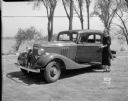
| Date: | 05 22 1933 |
|---|---|
| Description: | Janette Serrec, University of Wisconsin graduate, lecturer and writer on the "Fine Art of Successful Living," standing beside a Pontiac automobile she drov... |

| Date: | 1968 |
|---|---|
| Description: | Ansel Adams takes exposure notes during a photo shoot at Point Lobos. |
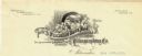
| Date: | 1887 |
|---|---|
| Description: | Letterhead of the La Crosse Wallis Carriage Co., manufacturers of fine family carriages, showing a view of the factory with the Mississippi River in the ba... |

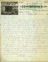
| Date: | 03 10 1902 |
|---|---|
| Description: | Syl, wearing a sailor suit and cap, carves his name into a tree. To the left is a deck suspended over a steep hill. Below is a lake or river. |

| Date: | 1908 |
|---|---|
| Description: | Front and back of a postcard sent from Agnes to William (Bill) Quinney. The front features a print of the Cliffs of Dover in pastel tones while, on the ba... |

| Date: | 1930 |
|---|---|
| Description: | The front and back of a postcard featuring a drawing of the Detroit skyline as seen from Windsor, Ontario that was sent by Alice and Floyd Quinney during t... |
| Date: | |
|---|---|
| Description: | Letterhead of the Wisconsin Bank Note and Lithographing Company of Milwaukee, Wisconsin, with a child writing on a tablet and perching on a banner bearing ... |

| Date: | 1863 |
|---|---|
| Description: | This map is a hand-colored, pen and ink, drawing by Ole R. Dahl of Co. B, 15 Wisconsin Infantry shows the battlefield at Stones River, depicting roads, str... |
| Date: | 05 24 1820 |
|---|---|
| Description: | A page, headed with "Journal No. 1," of James Doty's journal of a trip with Cass, Schoolcraft, etc. to the sources of the Mississippi River. |

| Date: | 10 19 1836 |
|---|---|
| Description: | This 1836 manuscript map shows the sections, windfalls, marshes, streams, prairies, acreages, and former mouth of the Pike River in what is now the eastern... |

| Date: | 08 17 1874 |
|---|---|
| Description: | This manuscript drawing provides a side elevation, plan, and perspective view for a proposed lock on the Fox River. |

| Date: | 1905 |
|---|---|
| Description: | This pictorial representation of part of Lake Winnebago and the Fox River in 1703, showing interactions between white beaver hunters and the Iroquois is ta... |

| Date: | 06 1837 |
|---|---|
| Description: | Pen-and-ink on paper. Shows riverside property west of the Milwaukee River. Inscribed by several early Milwaukee settlers, including Henry W. Cleveland, Cy... |
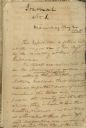
| Date: | 1887 |
|---|---|
| Description: | Opening spread of Reuben Gold Thwaites' diary of his 1887 trip on the Fox River. |
| Date: | 1906 |
|---|---|
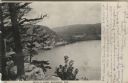
| Description: | View from bluff of Devil's Lake. A road runs along the far shoreline. Caption reads: "Devil's Lake, Baraboo, Wis." |
| Date: | 1907 |
|---|---|
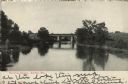
| Description: | View over water towards a railroad bridge over a river. Trees and shrubs are along the banks of the river. There are buildings in the distance behind the b... |
| Date: | 1920 |
|---|---|
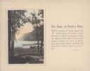
| Description: | A hand-tinted photograph of a scene along the wooded shore of Devil's Lake is mounted on a piece of beige paper. The scene features an old section of a woo... |
| Date: | 1920 |
|---|---|
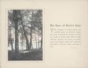
| Description: | A hand-tinted photograph of a tree-framed scene along the shore of Devil's Lake is mounted on a piece of beige paper. A large bluff dominates the backgroun... |

| Date: | 11 1836 |
|---|---|
| Description: | This map is pen-and-ink on paper and is a plat of a paper city on the Wisconsin River, in what is now the Town of Dekorra. The map shows lot and block numb... |

| Date: | 1948 |
|---|---|
| Description: | This map is ink on tracing paper and shows acreages, wards, streets, rivers, and Lake Michigan. Also included are editorial notes in pencil. |
If you didn't find the material you searched for, our Library Reference Staff can help.
Call our reference desk at 608-264-6535 or email us at: