 Filter: Categories of Wisconsin Historical Images
Filter: Subject of Water
Filter: Subject of trees
Filter: County of Grant
Filter: Categories of Wisconsin Historical Images
Filter: Subject of Water
Filter: Subject of trees
Filter: County of Grant
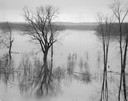
| Date: | 04 18 1965 |
|---|---|
| Description: | Wisconsin River in flood, looking downstream. |

| Date: | 1869 |
|---|---|
| Description: | Birds-eye drawing of Boscobel, Grant County, depicts street names and street layouts, houses, rivers and trees. A reference key at the bottom of the map sh... |

| Date: | 1875 |
|---|---|
| Description: | Bird's-eye map of Platteville. |

| Date: | 1829 |
|---|---|
| Description: | Drawing of Cassville depicting a horse cart on the river's edge, with men and boats. |
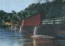
| Date: | 1930 |
|---|---|
| Description: | View of covered bridge, built in 1890, over the Wisconsin River with surrounding landscape. |
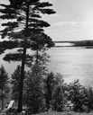
| Date: | 1940 |
|---|---|
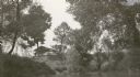
| Description: | View down steep hill through trees towards a rowboat tied to a pier on High Lake, with the far shoreline in the distance. |

| Date: | 1920 |
|---|---|
| Description: | Bridge over river from shoreline seen through trees in the spring or summer. Part of the bridge is covered. |
| Date: | 1920 |
|---|---|
| Description: | View across water towards the partially covered bridge. A wooded shoreline is along the left and right. |

| Date: | 1920 |
|---|---|
| Description: | Aerial view of the last covered bridge, which is no longer standing. |

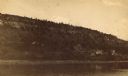
| Date: | 1900 |
|---|---|
| Description: | Elevated view of the brewery dwarfed by the overhead bluffs. The brewery was built by William Schmitz. George Scheibl ran the brewery from 1899 until his d... |
| Date: | |
|---|---|
| Description: | Cassville from the bluffs. Bluffs are in the right side of the image, and the view overlooks the town. The church is the dominant structure, and the river ... |

| Date: | |
|---|---|
| Description: | Elevated view from bluff of a house in Cassville surrounded by bluffs, trees and farmland. Railroad tracks run between the crops and the trees, and the Mis... |
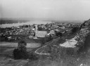
| Date: | 1900 |
|---|---|
| Description: | Aerial view of town. The Mississippi River and far shoreline is in the background. The Furnace Branch creek runs through the town in the foreground. |
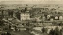
| Date: | |
|---|---|
| Description: | An engraving based on a drawing by Alexander Simplot of the Platteville Brewery (spelled Plattville). It is an elevated perspective showing the main buildi... |
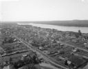
| Date: | 1887 |
|---|---|
| Description: | View over Mississippi River of town on shoreline with bluff in the background. |

| Date: | 1945 |
|---|---|
| Description: | Wyalusing State Park in the Prairie du Chein vicinity. The Wisconsin River is in the foreground and the Mississippi river can be seen below with distant bl... |
| Date: | 1920 |
|---|---|
| Description: | View across water towards the C.R. Pickering Camp on Mill Creek, in summer. The shelter is on a hill overlooking the pond. |
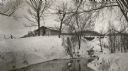
| Date: | 1920 |
|---|---|
| Description: | C.R. Pickering Camp on Mill Creek, in winter with snow on the ground. On the opposite shoreline is a shelter on the hill overlooking the creek, with a set ... |
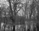
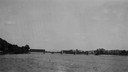
| Date: | 04 18 1965 |
|---|---|
| Description: | View of a wooded area affected by a Wisconsin River flood. |
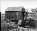
| Date: | |
|---|---|
| Description: | Small wooden building with water wheel, presumably a mill. |
If you didn't find the material you searched for, our Library Reference Staff can help.
Call our reference desk at 608-264-6535 or email us at: