 Filter: Categories of Wisconsin Historical Images
Filter: Subject of Water
Filter: Subject of suburbs
Filter: Categories of Wisconsin Historical Images
Filter: Subject of Water
Filter: Subject of suburbs

| Date: | 1892 |
|---|---|
| Description: | Color bird's-eye map of Wauwatosa, looking east toward Milwaukee and Lake Michigan. Predominantly green with cream colored roadways, with six land plots ow... |
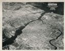
| Date: | 1948 |
|---|---|
| Description: | Aerial view of downtown area, with the Fox River and neighboring suburbs. |
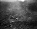
| Date: | 04 21 1948 |
|---|---|
| Description: | Aerial photograph of the west side of Madison and the western edge of Lake Mendota. Taken over the west side of Madison looking northwest toward Middleton. |
| Date: | |
|---|---|
| Description: | A street cleaning truck spraying water on a suburban street with houses in the background. The text on the driver's side door probably reads "US Dept. of A... |
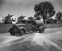
| Date: | 12 1938 |
|---|---|
| Description: | A device spraying water to create an ice rink. The rink was 115 x 200 ft. and was opened sometime during Christmas week 1938. There are houses and pedestri... |

| Date: | |
|---|---|
| Description: | Rainwater pooling on the curb and in the driveway of a residence. A garage and well-groomed yard is also visible. A tricycle and coaster wagon are on a wal... |
| Date: | |
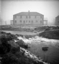
|---|---|
| Description: | The Root River swollen with rainwater and/or snow melt. A recently built duplex housing unit is visible in the background. This picture was likely taken as... |
| Date: | |
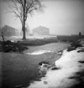
|---|---|
| Description: | The Root River, swollen with rainwater and/or snow melt, runs under a bridge on which a man is walking. Recently built houses are visible in the misty back... |
| Date: | |
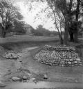
|---|---|
| Description: | Rocks placed to control the flow of Dale Creek. A house is visible in the background. This picture was likely taken as a study of the water drainage in ear... |
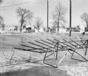
| Date: | |
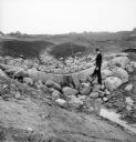
|---|---|
| Description: | A man stands on rocks that will dam Dale Creek. This picture was likely taken for a study of the water drainage system in early Greendale. |
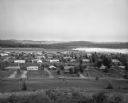
| Date: | 07 24 1966 |
|---|---|
| Description: | Elevated view of small town. A Lake Wisconsin is visible beyond the town limits. |

| Date: | 1950 |
|---|---|
| Description: | This map is accompanied by booklet: "Know Milwaukee Map and Street Guide". The map is a detailed map of Milwaukee and the surrounding suburbs. Streets and ... |
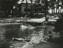
| Date: | 1957 |
|---|---|
| Description: | Suburban upper-class residence in wooded area with rock-lined swimming pool and swimming children. Two women sit in lawn chairs on the lawn near the house ... |

| Date: | 04 04 1934 |
|---|---|
| Description: | Street map of the city of Milwaukee and surrounding communities at a scale of 1 inch to 1200 feet. |

| Date: | 1906 |
|---|---|
| Description: | This map shows shows streets, subdivisions, railroads, places of interest including the State Capitol, the University of Wisconsin, Camp Randall, Henry Vil... |

| Date: | 1966 |
|---|---|
| Description: | This map shows streets, highways, railroads, parks, colleges, cemeteries, county clubs, University of Wisconsin, Truax Field, Middleton, Shorewood Hills, M... |

| Date: | 1969 |
|---|---|
| Description: | This map is pen and ink on paper and shows the location of churches, local streets, railroads, parks, Middleton, Shorewood Hills, Monona, Maple Bluff, McFa... |

| Date: | 1968 |
|---|---|
| Description: | Three maps that show local streets, roads, railroads, parks, country clubs, the University of Wisconsin, Shorewood Hills, Maple Bluff, Monona, Truax Field,... |

| Date: | 1971 |
|---|---|
| Description: | This map shows streets, highways, railroads, parks, colleges, cemeteries, county clubs, University of Wisconsin, Truax Field, Middleton, Shorewood Hills, M... |

| Date: | 1960 |
|---|---|
| Description: | This blue print map shows village limits, collector residential streets, and primary residential streets. The upper right corner features a key to street t... |
If you didn't find the material you searched for, our Library Reference Staff can help.
Call our reference desk at 608-264-6535 or email us at: