Filter: Categories of Wisconsin Historical Images
Filter: Subject of Water
Filter: Subject of persons
Filter: Subject of express highways
Filter: Categories of Wisconsin Historical Images
Filter: Subject of Water
Filter: Subject of persons
Filter: Subject of express highways
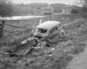
| Date: | 10 23 1937 |
|---|---|
| Description: | Close-up of damaged Chevrolet in a ditch next to Highway 12 near Highway KP & Roxbury, looking north, with a farmstead in the background. |

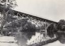
| Date: | 1930 |
|---|---|
| Description: | View of bridge and Brule River monument. Placed where the Brule River is crossed by the Memorial Highway from Superior to Brule and Ashland (Highway 2). |
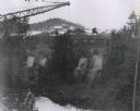
| Date: | 1960 |
|---|---|
| Description: | Excavation for bridge column footings for the Mirror Lake Bridge. |
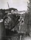
| Date: | 11 16 1960 |
|---|---|
| Description: | Elevated view of the interstate highway bridge construction at Mirror Lake showing the concrete footings halfway down the embankment. |
| Date: | 06 1977 |
|---|---|
| Description: | A view of the St. Croix River crossing at Hudson during the development of the Interstate Bridge. The old eastbound bridge seen here was built in 1951 whil... |

| Date: | 1961 |
|---|---|
| Description: | View over beltline of University of Wisconsin-Madison Arboretum along Lake Wingra. Lake Mendota is on upper left, and Lake Monona is on the right, with the... |
| Date: | 1937 |
|---|---|
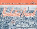
| Description: | Cover of a brochure celebrating a new International Harvester Manhattan branch, featuring an aerial photograph of Manhattan, including the corner of West 4... |
| Date: | 1972 |
|---|---|
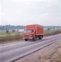
| Description: | Color photograph of a man driving an International truck past a body of water in what appears to be a golf course. |

| Date: | 1944 |
|---|---|
| Description: | Continental Transportation Lines, Inc. operating an International semi-truck (tractor-trailer) on a road with a hazy view of a bridge, a body of water and ... |

| Date: | 12 25 1942 |
|---|---|
| Description: | This hand-drawn map shows the highways and features in the Rock Lake-Lake Mills area in the towns of Aztalan and Lake Mills, Jefferson County, Wisconsin. T... |

| Date: | 1976 |
|---|---|
| Description: | A street map of Milwaukee County, Wisconsin that identifies the location of schools, hospitals, parks, beaches, streets, freeways, both planned or under co... |

| Date: | 10 1961 |
|---|---|
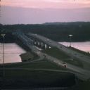
| Description: | View from hill towards cars driving over a bridge spanning the Wisconsin River (I90/I94/I39). |

| Date: | 12 01 1928 |
|---|---|
| Description: | View down highway towards a truck coming up the road. There is a long guardrail on the left, with a steep bank rising up pon the right. The highway is runn... |
If you didn't find the material you searched for, our Library Reference Staff can help.
Call our reference desk at 608-264-6535 or email us at: