 Filter: Categories of Wisconsin Historical Images
Filter: Subject of Water
Filter: Subject of persons
Filter: Subject of aids to navigation
Filter: Categories of Wisconsin Historical Images
Filter: Subject of Water
Filter: Subject of persons
Filter: Subject of aids to navigation
| Date: | |
|---|---|
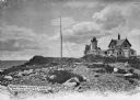
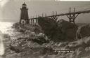
| Description: | Eastern Point Lighthouse at "Mother Ann" and residence on rocky point, Gloucester, Massachusetts. Mother Ann is a rocky cliff at the far south end of Easte... |
| Date: | |
|---|---|
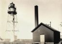
| Description: | La Pointe Light on Long Island (Apostle Islands), Chequamegon Bay, Lake Superior. |
| Date: | 07 22 1949 |
|---|---|
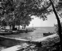
| Description: | Tenney Park breakwater and Lake Mendota. The city of Madison was able to resume construction at no cost. The construction company tearing up East Washingto... |

| Date: | 1890 |
|---|---|
| Description: | View from the shore of Kenosha's North Pier and lighthouse. Waves are breaking on the shore of Lake Michigan. |
| Date: | |
|---|---|
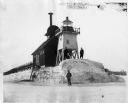
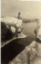
| Description: | Three men pose standing on ice around North Pier lighthouse. In the background is the town along the shoreline. |
| Date: | |
|---|---|
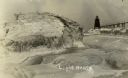
| Description: | View of ice coated pier and lighthouse along the shore of Lake Michigan. Caption reads: "Winter Scene at Port Washington, Wis." |
| Date: | |
|---|---|
| Description: | Postcard view along icy shoreline of the pier and lighthouse on Lake Michigan at Port Washington in winter. |
| Date: | |
|---|---|
| Description: | Winter postcard view of the pier and lighthouse at Port Washington seen from the icy shore of Lake Michigan. Caption reads: "Light House." |
| Date: | |
|---|---|
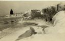
| Description: | Winter view of the lighthouse at Port Washington from the icy shore of Lake Michigan. Two people can be seen standing on a pier in the distance. |
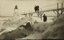
| Date: | 1910 |
|---|---|
| Description: | Postcard view of three men on an elevated walk on an icy pier near the shoreline. A women and young boy stand on the pier below the walk. There is a lighth... |
| Date: | |
|---|---|
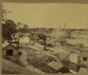
| Description: | Elevated view of a lock at Appleton, with views of mills and other structures in the background. |

| Date: | 1733 |
|---|---|
| Description: | This map of North America shows settlements, rivers, lakes, Native American land, trade winds, and numerous topographical features such as forests and moun... |
If you didn't find the material you searched for, our Library Reference Staff can help.
Call our reference desk at 608-264-6535 or email us at: