 Filter: Categories of Wisconsin Historical Images
Filter: Subject of Water
Filter: Subject of methodist churches
Filter: Categories of Wisconsin Historical Images
Filter: Subject of Water
Filter: Subject of methodist churches
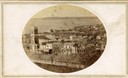
| Date: | |
|---|---|
| Description: | View of North Pinckney Street from the Capitol roof. The Methodist Episcopal church is located in the left of this image. |
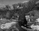
| Date: | 1950 |
|---|---|
| Description: | View looking up at the Methodist Episcopal church over tree covered formations on the banks of Arkansaw Creek. |
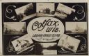
| Date: | 11 16 1908 |
|---|---|
| Description: | Photographic COLLAGE postcard of scenes of Colfax. In the center oval is the text, "Colfax, Wis. Looks Good To Me," however the "Looks Good To Me" is cross... |

| Date: | 1969 |
|---|---|
| Description: | This map is pen and ink on paper and shows the location of churches, local streets, railroads, parks, Middleton, Shorewood Hills, Monona, Maple Bluff, McFa... |

| Date: | 1857 |
|---|---|
| Description: | This map shows rural landownership and acreages, lot and block numbers, selected buildings, roads, railroads, and public squares. The map is indexed for th... |

| Date: | 1905 |
|---|---|
| Description: | Hand-colored view of the Methodist Episcopal Church on Portland Avenue. Cedar Creek flows behind it. Caption reads: "M.E. Church, Cedarburg, Wis." |
If you didn't find the material you searched for, our Library Reference Staff can help.
Call our reference desk at 608-264-6535 or email us at: