Visit our other Wisconsin Historical Society websites!
 Filter: Categories of Wisconsin Historical Images
Filter: Subject of Water
Filter: Subject of intellectual life
Filter: Categories of Wisconsin Historical Images
Filter: Subject of Water
Filter: Subject of intellectual life

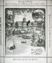
| Date: | 02 21 1882 |
|---|---|
| Description: | Chromolithograph poster advertising a Milwaukee Mardi Gras celebration, arranged by the Turnverein and Milwaukee Musical Societies, and held at the Exposit... |
| Date: | 1904 |
|---|---|
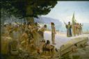
| Description: | Jean Nicolet (1598-1642) was the first European to see Wisconsin and was a prominent French explorer who, for many years, lived among the Indians of Quebec... |

| Date: | 1952 |
|---|---|
| Description: | Aerial view of a North Central Airlines DC-3 airplane flying over the Madison isthmus. Clearly visible are the Wisconsin State Capitol, the 1 West Wilson S... |

| Date: | 09 1871 |
|---|---|
| Description: | Bird's-eye view of Peshtigo, before it was destroyed by fire on the night of October 8, 1871. |

| Date: | 1940 |
|---|---|
| Description: | Aerial view looking east over the center of the city and the University of Wisconsin-Madison campus. |
| Date: | 1921 |
|---|---|
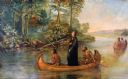
| Description: | Painted scene of an Indian guide paddling, Jacques Marquette, a Jesuit missionary standing, and Louis Joliet, a fur trader paddling in a canoe exploring th... |

| Date: | 1870 |
|---|---|
| Description: | This bird's-eye-view map shows roads, a river with boats, and homes. The bottom margin of the map includes an index. |

| Date: | 1881 |
|---|---|
| Description: | Bird's-eye map of Marinette, with insets. |

| Date: | 1855 |
|---|---|
| Description: | Bird's-eye view of Madison. "Taken from the Water Cure, South Side of Lake Monona, 1855." |

| Date: | 1823 |
|---|---|
| Description: | In 1823 U.S. Army major Stephen H. Long led an expedition of scientific, trade, and military investigation up the Mississippi River and the Red River of th... |

| Date: | 1908 |
|---|---|
| Description: | Colored map showing a panoramic view of Madison in great detail. The Wisconsin State Capitol is located at the center, with Lake Mendota in the background ... |

| Date: | 1950 |
|---|---|
| Description: | Aerial view of the Wisconsin State Capitol building and surrounding Madison area. Lake Monona is in the background. |

| Date: | 1884 |
|---|---|
| Description: | A sign for Fauerbach's Brewery depicting a young woman and the brewery. |
| Date: | 1925 |
|---|---|
| Description: | Aerial view of Woods' Manor on shores of Madeline Island. The manor was built in 1900 for summer resident Colonel Frederick Woods from Nebraska. |
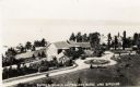
| Date: | 1883 |
|---|---|
| Description: | Tonyawatha Spring Hotel from a descriptive brochure. The hotel opened in 1879 and was destroyed by fire on July 31, 1895. |
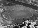
| Date: | 1952 |
|---|---|
| Description: | Aerial view of City Stadium, former home of the Green Bay Packers from 1925 to 1956. Currently it is the home of the Green Bay East High School football te... |

| Date: | 1886 |
|---|---|
| Description: | Bird's-eye view of Ashland, on the shores of Lake Superior, with insets of The Apostle Islands Chequamagon Bay & Ashland, and Distances from Ashland. |

| Date: | 1880 |
|---|---|
| Description: | Bird's-eye view of Jefferson on the Rock River. |

| Date: | 1907 |
|---|---|
| Description: | Bird's-eye view of the University of Wisconsin-Madison campus looking northwest. Building at top of hill, to left of center is Bascom Hill (Main Hall) and... |
If you didn't find the material you searched for, our Library Reference Staff can help.
Call our reference desk at 608-264-6535 or email us at:
