 Filter: Categories of Wisconsin Historical Images
Filter: Subject of Water
Filter: Subject of insurance
Filter: Categories of Wisconsin Historical Images
Filter: Subject of Water
Filter: Subject of insurance
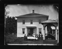
| Date: | 1879 |
|---|---|
| Description: | Here Dahl used "The Old Oaken Bucket" motif — a man drinking water from a pail at a well in foreground with family sitting and standing at a table with cof... |

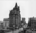
| Date: | 1910 |
|---|---|
| Description: | Panoramic bird's-eye view of the heart of the Loop. Labeled sites include: Insurance Exchange, Continental and Commercial National Bank, Post Office, Dear... |
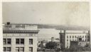
| Date: | 1903 |
|---|---|
| Description: | Elevated view from Wisconsin River looking east. The Pabst Building is on the northwest corner of N. Water Street and E. Wisconsin Avenue with the Mack bui... |

| Date: | 08 15 1949 |
|---|---|
| Description: | Herman & Lily Ekern, right, are honored on the eve of their 50th wedding anniversary at a luncheon at the Edgewater Hotel. On the left are Mr. & Mrs. J.A.O... |
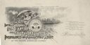
| Date: | |
|---|---|
| Description: | Letterhead proof for the International Litho Artists and Engravers Insurance and Protective Association of the United States and Canada, of Milwaukee, Wisc... |

| Date: | |
|---|---|
| Description: | Battleship U.S.S. Wisconsin at sea with several men on deck. The mounted photograph was a promotional item for Northwestern National Insurance, Co. |

| Date: | 1912 |
|---|---|
| Description: | Shows wards, sections, plat additions, selected buildings, churches, schools, and manufacturing companies. "We have revised this map from H. McCallum’s 189... |

| Date: | 1908 |
|---|---|
| Description: | Title at top: "G.F. Sanborn Company Timber and Farming Lands." Map shows acreages, roads, railroads, and swamps in parts of Vilas and Oneida counties. |
| Date: | 1930 |
|---|---|
| Description: | Elevated view to the south from the Capitol Square. The large building on the left is the original first National Bank that was demolished to make way for ... |

| Date: | 09 1918 |
|---|---|
| Description: | An insurance map of Washburn, with an index and a key. Includes a small inset map of the State of Wisconsin that shows "Location of this town as above unde... |
If you didn't find the material you searched for, our Library Reference Staff can help.
Call our reference desk at 608-264-6535 or email us at: