 Filter: Categories of Wisconsin Historical Images
Filter: Subject of Water
Filter: Subject of human settlements
Filter: Year of 2000-Present
Filter: Categories of Wisconsin Historical Images
Filter: Subject of Water
Filter: Subject of human settlements
Filter: Year of 2000-Present

| Date: | 11 16 2001 |
|---|---|
| Description: | Aerial view of General Mitchell International in Milwaukee, looking southeast to the Lake Michigan shoreline. |

| Date: | 2007 |
|---|---|
| Description: | This map of Cedarbug is a bird's-eye map with 8 inset views and an index. The map is a print out of the original map dated 1892 held at the Cedarburg Cultu... |
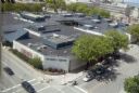
| Date: | 08 2008 |
|---|---|
| Description: | Elevated view of University Square shopping mall between West Johnson Street and University Avenue. (Demolished June 2006). Photograph taken from Witte Hal... |
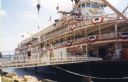
| Date: | 2004 |
|---|---|
| Description: | The "Delta Queen" steamboat at dock. People are walking across the gangplank toward the shoreline. |
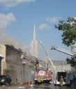
| Date: | 07 30 2011 |
|---|---|
| Description: | Firefighters respond to a fire at the Democratic Party Office at 118 Fifth Avenue. Viewed from Fourth Street intersection. |

| Date: | 2013 |
|---|---|
| Description: | Map is the most extensive endeavor to date to accurately locate and document both prehistoric place names and natural features of the Menominee language wi... |

| Date: | 07 2003 |
|---|---|
| Description: | This Barton dam is the subject of a photo study. Anna Williams acts as a model. |

| Date: | 04 10 2014 |
|---|---|
| Description: | The owner of La Crosse Radio Group, Jacklyn Daniels, gazes out of the window at the riverside. The event was the DMI Trend Showcase in the Cargill Room. S... |
| Date: | 2000 |
|---|---|
| Description: | This map shows railroads by operating freight and government agencies, Amtrak stations, ports, rail lines out of service, rail banks, and Rails-to-Trails. ... |

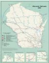
| Date: | 2003 |
|---|---|
| Description: | The front of map shows trails throughout the bottom half of Wisconsin and includes text on snowmobile rules and tourism contacts. The reverse shows trails ... |

| Date: | 2000 |
|---|---|
| Description: | This map shows national parks, county and state forests, Indian reservations, municipal land, private land, docks, boat access, camping, and points of inte... |
| Date: | 2012 |
|---|---|
| Description: | This map includes a descriptive index of galleries and studios with color illustrations, on both sides. |
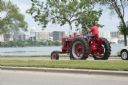
| Date: | 2010 |
|---|---|
| Description: | A man drives a tractor on John Nolen Drive along Lake Mendota with the Wisconsin State Capitol in the distance. He is on his was to a Red Power venue held ... |
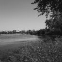
| Date: | 08 2013 |
|---|---|
| Description: | View from shoreline of natural plants and trees towards the Madison skyline from across Monona Bay. A line of high-rise buildings frame the Wisconsin State... |

| Date: | 2004 |
|---|---|
| Description: | This map shows ATMs, houses of worship, hotels, parking ramps, public parking, union cab stands, bus stops, business district, parks and public areas, gove... |

| Date: | 2000 |
|---|---|
| Description: | This map shows the industrial area along the Menominee River and canals. Industrial buildings are shown in orange and labeled in red. Other areas are shown... |

| Date: | 2005 |
|---|---|
| Description: | This map shows dams and falls, areas of portage, canoe and kayak access, boat launches, parking, restrooms, picnic areas, dining, rapid water, parks, and b... |
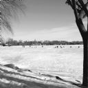
| Date: | 01 2014 |
|---|---|
| Description: | View from shoreline on a sunny day of snow-covered, frozen Monona Bay. People in the distance are standing or sitting near ice fishing holes and ice fishin... |

| Date: | 04 2014 |
|---|---|
| Description: | View down sidewalk towards the Holy Wisdom Monastery. In the distance is Lake Mendota, which is just beyond a field of tall grass and trees. The building h... |
| Date: | 05 2014 |
|---|---|
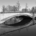
| Description: | View across water towards the weathered footbridge spanning the Tenney Park lagoon near Marston Avenue. The word "Marston" is carved into the side of the b... |
If you didn't find the material you searched for, our Library Reference Staff can help.
Call our reference desk at 608-264-6535 or email us at: