Filter: Categories of Wisconsin Historical Images
Filter: Subject of Water
Filter: Subject of human settlements
Filter: Categories of Wisconsin Historical Images
Filter: Subject of Water
Filter: Subject of human settlements

| Date: | 1848 |
|---|---|
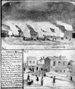
| Description: | In 1849, northern Wisconsin was composed of huge sectional regions such as Chippewa, Portage, Brown and Crawford, whereas southern Wisconsin was constitute... |

| Date: | 1873 |
|---|---|
| Description: | Newspaper reproduction of an etching of the Milwaukee River. |

| Date: | 1964 |
|---|---|
| Description: | Aerial view of the Milwaukee County Zoo grounds nearing its completion. |
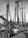
| Date: | |
|---|---|
| Description: | View downriver from the State Street Bridge showing a large sailing vessel. |
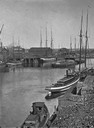
| Date: | |
|---|---|
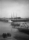
| Description: | View down the river toward the Bay from Walker's Point Bridge, showing several steamboats. |
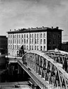
| Date: | |
|---|---|
| Description: | Exterior view of the Axtell House with Walker's Point Bridge in the foreground. |
| Date: | |
|---|---|
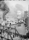
| Description: | Elevated view of a Milwaukee River scene showing people watching several steamboats from a bridge. |
| Date: | |
|---|---|
| Description: | A view of the D.G. & M. Depot from the East Water Street Bridge. |
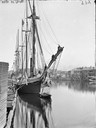
| Date: | |
|---|---|
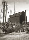
| Description: | View of old sailing boats at a shoreline with elevator A in the background. |
| Date: | 11 08 1906 |
|---|---|
| Description: | Two Civil War watercolor drawings by John Gaddis, Company E, 12th Wisconsin Volunteer Infantry, showing the regiment in bivouac, and later their headquarte... |
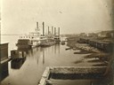
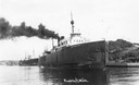
| Date: | |
|---|---|
| Description: | The sternwheel packet, Arkansas, next to a barge with other steamboats at the levee in Winona between 1870 and 1880. Railway cars are on a siding in... |
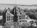
| Date: | 1958 |
|---|---|
| Description: | Elevated view of the Dane County Courthouse as it is being razed. Much of it is still intact in this image. Lake Monona and Monona Bay are in the distance. |

| Date: | 1856 |
|---|---|
| Description: | View looking west from Lake Michigan with several steam ships and sailing vessels in harbor. There is a lighthouse to left of center, along shoreline. |
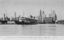
| Date: | |
|---|---|
| Description: | The screw passenger excursion vessel, "Christopher Columbus," leaving Chicago. Skyline of Chicago is in background with one building with sign reading Armo... |
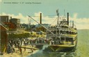
| Date: | 1901 |
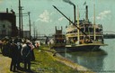
|---|---|
| Description: | The sternwheel excursion, J.S., landing passengers, taken between 1901 and 1910. Crowds are on riverbank and there are buildings in background. A cr... |
| Date: | |
|---|---|
| Description: | View along shoreline of the sternwheel excursion, J.S., getting ready to leave for Winona. A crowd is watching from the landing. A crane on the fron... |
| Date: | |
|---|---|
| Description: | The screw ferry, Ann Arbor No. 7, at Frankfort. Later named Viking, then Viking I. Caption reads: "Frankfort, Mich." |
If you didn't find the material you searched for, our Library Reference Staff can help.
Call our reference desk at 608-264-6535 or email us at: