Filter: Categories of Wisconsin Historical Images
Filter: Subject of Water
Filter: Subject of human settlements
Filter: County of Columbia
Filter: Categories of Wisconsin Historical Images
Filter: Subject of Water
Filter: Subject of human settlements
Filter: County of Columbia

| Date: | 1936 |
|---|---|
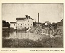
| Description: | This map is red and black ink on tracing cloth and is oriented with north to the upper left. This hand-drawn map shows a central portion of the military ro... |

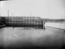
| Date: | 1910 |
|---|---|
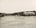
| Description: | View down the canal, with buildings along the shoreline, and a boat coming down the canal. |
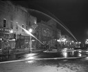
| Date: | 04 15 1950 |
|---|---|
| Description: | Fire fighters from neighboring communities help put out at a nighttime fire in the downtown business district. |
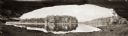
| Date: | 1900 |
|---|---|
| Description: | Panoramic view of the Wisconsin River in the Wisconsin Dells from underneath an overhanging rocky outcropping. A canoe is beached on the far left. The word... |

| Date: | 1868 |
|---|---|
| Description: | This 1868 birds-eye view depicts the buildings, streets, railroad, vegetation and topography of Columbus, Wisconsin. The high school, cemetery, railroad de... |
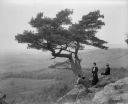
| Date: | 1902 |
|---|---|
| Description: | Two women and a man pose atop Gibraltar Rock in Richmond Memorial Park, which was dedicated by Jens Jensen and the Wisconsin Friends in 1927 in order to co... |

| Date: | 1868 |
|---|---|
| Description: | Bird's-eye map of Portage, with insets of the Court House and the Public School. |

| Date: | 1870 |
|---|---|
| Description: | Bird's-eye map of Kilbourn City, now known as Wisconsin Dells. Kilbourn City was platted in the 1850s and received a boost when the La Crosse and Milwaukee... |

| Date: | 1874 |
|---|---|
| Description: | Bird's-eye map of Lodi, with inset of Public School. Includes index of churches and points of interest. |

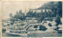
| Date: | |
|---|---|
| Description: | View from the Sherman House porch overlooking the river. |
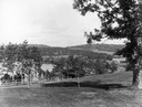
| Date: | |
|---|---|
| Description: | View from the Sherman House overlooking expansive lawn and river. |
| Date: | 1930 |
|---|---|
| Description: | Aerial view of the town of Wisconsin Dells, the dam on the Wisconsin River, and the generating plant. The town of Wisconsin Dells was known as Kilbourn Cit... |
| Date: | 1910 |
|---|---|
| Description: | Elevated view across water toward the Larks Hotel and ferry. Caption reads: "Larks Hotel, Wisconsin Dells." |
| Date: | 1959 |
|---|---|
| Description: | The Kilbourn Hydroelectric Plant of the Wisconsin Power and Light Company. |
| Date: | |
|---|---|
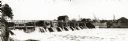
| Description: | Kilbourn Dam under construction on the Wisconsin River by the Southern Wisconsin Power Company. |

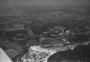
| Date: | 1930 |
|---|---|
| Description: | Aerial view of Wisconsin Dells including the Wisconsin River and the dam and generating power plant. |

| Date: | 1878 |
|---|---|
| Description: | Kilbourn Bridge at the Wisconsin Dells, Wisconsin. A locomotive is pulling railroad cars over the bridge. |
If you didn't find the material you searched for, our Library Reference Staff can help.
Call our reference desk at 608-264-6535 or email us at: