 Filter: Categories of Wisconsin Historical Images
Filter: Subject of Water
Filter: Reproduction Rights of Special Conditions
Filter: Subject of transportation
Filter: Subject of human settlements
Filter: Categories of Wisconsin Historical Images
Filter: Subject of Water
Filter: Reproduction Rights of Special Conditions
Filter: Subject of transportation
Filter: Subject of human settlements

| Date: | 1964 |
|---|---|
| Description: | Aerial view of the Milwaukee County Zoo grounds nearing its completion. |
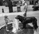
| Date: | 07 20 1987 |
|---|---|
| Description: | A little girl offers her place at a fountain to a large Newfoundland-mix dog who takes a drink on a hot day. |

| Date: | 1883 |
|---|---|
| Description: | Bird's-eye map of Manitowoc. |

| Date: | 05 02 1964 |
|---|---|
| Description: | Sitting on the school lawn, students draw Highway 51, Marathon Mill, Rib mountain and the Wisconsin River. |
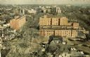
| Date: | 1964 |
|---|---|
| Description: | Elevated view of the city looking north along the shore of Lake Michigan. |

| Date: | 1959 |
|---|---|
| Description: | Aerial view of the island of Cuba taken from a small plane. Part of the plane with a Cuban flag painted on it is in the frame, and the island with many bui... |

| Date: | 2013 |
|---|---|
| Description: | Map is the most extensive endeavor to date to accurately locate and document both prehistoric place names and natural features of the Menominee language wi... |

| Date: | 1941 |
|---|---|
| Description: | A detail of a Sanborn map showing areas at Langdon and Henry Streets, including Lake Lawn Place. |

| Date: | 07 25 1967 |
|---|---|
| Description: | Newspaper caption reads: "Passersby don't know it, but what appears to be a coonskin cap around the neck of Todd Vasas, 16, of 2773 S. Shore Drive, is the ... |

| Date: | 1942 |
|---|---|
| Description: | Detail of a Madison Sanborn Map showing the Lake Mendota shoreline. The area shown is between the Blackhawk Country Club and Eagle Heights Woods. |

| Date: | 2010 |
|---|---|
| Description: | A man drives a tractor on John Nolen Drive along Lake Mendota with the Wisconsin State Capitol in the distance. He is on his was to a Red Power venue held ... |
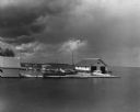
| Date: | 08 1951 |
|---|---|
| Description: | Threatening skies loom over boats, piers and boathouses in Eagle harbor. |
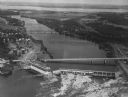
| Date: | 1950 |
|---|---|
| Description: | Aerial view of a hydroelectric power plant owned by Northern States Power Company located on the Chippewa River. A highway bridge and a railroad bridge spa... |
| Date: | 1955 |
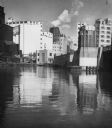
|---|---|
| Description: | Industries along the Milwaukee River, one of which is the Schlitz Brewery. |
| Date: | 02 18 1958 |
|---|---|
| Description: | The SS Meteor, a Great Lakes cargo steamship of whaleback design, coming into harbor. The ship is covered with snow and ice and the surface of the l... |
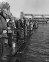
| Date: | 1960 |
|---|---|
| Description: | View of a crowd of people lined up fishing side by side on long pier. A railroad bridge, with a tanker car, is in the background. |

| Date: | 03 1962 |
|---|---|
| Description: | The Stone Bank Presbyterian Church reflected in standing water in springtime. Trees are in the background. |

| Date: | 1963 |
|---|---|
| Description: | Boats moored at a boat slip. In the foreground is a bench near a concrete wall over which rope is hanging in loops. |
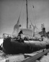
| Date: | 1963 |
|---|---|
| Description: | Fish nets and floats drying while wound onto wooden reels. Clouds are in the sky in the background. |
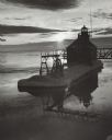
| Date: | 03 1969 |
|---|---|
| Description: | The Sturgeon Bay Ship Canal Pierhead Lighthouse silhouetted against the sun shining through the clouds. Snow covers the pier, and ice is floating on the la... |
If you didn't find the material you searched for, our Library Reference Staff can help.
Call our reference desk at 608-264-6535 or email us at: