 Filter: Categories of Wisconsin Historical Images
Filter: Subject of Water
Filter: County of Portage
Filter: Categories of Wisconsin Historical Images
Filter: Subject of Water
Filter: County of Portage

| Date: | 1891 |
|---|---|
| Description: | Bird's-eye map of Stevens Point, looking east, with an inset of the Water Works. Wisconsin River in foreground with fifty-three business locations identifi... |
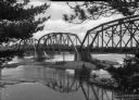
| Date: | |
|---|---|
| Description: | Colorized view depicting the Wisconsin Central Railroad bridge at Stevens Point, with several men standing on top of the bridge painting the structure. Cap... |
| Date: | 1958 |
|---|---|
| Description: | Plover River Pond; the dam was out and the pond is dry, permitting an unusual view of the immediate area. Highway 51 and a bridge can be seen in the distan... |
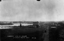
| Date: | 1898 |
|---|---|
| Description: | Elevated view of the Jackson Milling Company, the Green Bay railroad tracks, and the Wisconsin Central railroad tracks. Caption reads: "Birdseye View of Ri... |
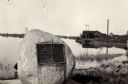
| Date: | 1925 |
|---|---|
| Description: | View of the Stevens monument, erected in honor of George Stevens, whom the town is named after, at the site where he landed in 1824. |

| Date: | 1920 |
|---|---|
| Description: | The Consolidated Papers, Inc., mill. "Either at Stevens Point or the Wisconsin River Division." |

| Date: | 1910 |
|---|---|
| Description: | View across grass towards a wagon bridge on the left crossing the Wisconsin River at Stevens Point. Caption reads: "Wagon Bridge, across Wisconsin River, S... |

| Date: | 1965 |
|---|---|
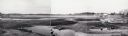
| Description: | Aerial view that encompasses most of the town and part of the Wisconsin River. |
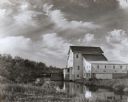
| Date: | 1950 |
|---|---|
| Description: | Grist mill. Two people with bicycles on bridge near mill. |

| Date: | 1905 |
|---|---|
| Description: | View looking east of logs floating in the pond at Scouler & Jacobson Lumber Company. Logs were dumped into the pond from the rollways on the left and sent ... |

| Date: | 11 29 1989 |
|---|---|
| Description: | Panoramic view of the Union Street Bridge in the village of Rosholt created by taping three images together. |

| Date: | |
|---|---|
| Description: | View of the Wisconsin River at River Pine Sanitarium, which opened in 1906. Boats are near a small dock to the right. |

| Date: | |
|---|---|
| Description: | View of a spring on the way to River Pine Sanitarium, which opened in 1906. |

| Date: | |
|---|---|
| Description: | View from shoreline toward the Plover River and dam. Factory buildings, barns, and residences are along the river's opposite bank. |

| Date: | |
|---|---|
| Description: | Individuals use rowboats near the shore of Marlin's Island on the Wisconsin River. |

| Date: | |
|---|---|
| Description: | View of a sandbar crowded with trees in the Wisconsin River. |
| Date: | |
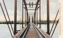
|---|---|
| Description: | Elevated view from shoreline toward construction workers standing on the Soo Line Railroad Bridge over the Wisconsin River. |

| Date: | |
|---|---|
| Description: | Exterior of the Consolidated Water Power and Paper Company, built in 1918. The view from across the Wisconsin River shows the company building, a dam, as w... |

| Date: | |
|---|---|
| Description: | Exterior of the Consolidated Water Power and Paper Company, built in 1918. The view from a bank of the Wisconsin River shows the company building and dam. |
If you didn't find the material you searched for, our Library Reference Staff can help.
Call our reference desk at 608-264-6535 or email us at:
