Filter: Categories of Wisconsin Historical Images
Filter: Subject of Water
Filter: County of Ozaukee
Filter: Categories of Wisconsin Historical Images
Filter: Subject of Water
Filter: County of Ozaukee
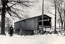
| Date: | 1940 |
|---|---|
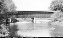
| Description: | Exterior view of the last covered bridge in Wisconsin. Caption reads: "Covered Bridge Near Cedarburg, Wis." |

| Date: | 1882 |
|---|---|
| Description: | This map of Cedarburg is a bird's-eye map with an inset of Cedarburg Brewery. Relief is shown pictorially and the map includes an index to buildings. |

| Date: | 2007 |
|---|---|
| Description: | This map of Cedarbug is a bird's-eye map with 8 inset views and an index. The map is a print out of the original map dated 1892 held at the Cedarburg Cultu... |
| Date: | |
|---|---|
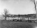
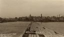
| Description: | View across field towards the railroad bridge, seen with the construction almost completed. A man is standing in the middle of the bridge, and two or three... |
| Date: | 1905 |
|---|---|
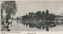
| Description: | View of Cedarburg across water. Caption reads: "Cedarburg, Wis." |
| Date: | 1934 |
|---|---|
| Description: | Southwest view of a covered bridge over Cedar Creek, with a man walking in the snow nearby. |
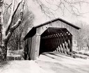
| Date: | 1957 |
|---|---|
| Description: | Covered bridge over Cedar Creek in Ozaukee County on highway, about one mile north of Cedarburg. The last remaining covered bridge in Wisconsin. Snow is on... |
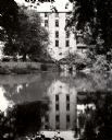
| Date: | 1950 |
|---|---|
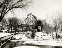
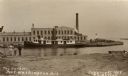
| Description: | The Thiensville Mill as seen from the waterfront. |
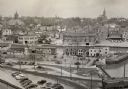
| Date: | 1952 |
|---|---|
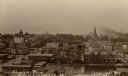
| Description: | An elevated view of the downtown section. |
| Date: | 1909 |
|---|---|
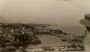
| Description: | Elevated view of town. A person is in the right foreground. Caption reads: "A Glimpse(?) of Port Washington, Wis." |
| Date: | 1909 |
|---|---|
| Description: | Elevated view of town. Caption reads: "Birdseye View Port Washington, Wis." |
| Date: | 1909 |
|---|---|
| Description: | View down Government Pier. In the distance are industrial buildings along the shoreline. Caption reads: "Gov't Pier Port Washington, Wis." |
| Date: | 1907 |
|---|---|
| Description: | View towards the shoreline of the harbor. A man, woman and child are standing at the shoreline on the left. Across the water is a boat along the opposite s... |
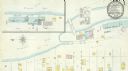
| Date: | 11 1894 |
|---|---|
| Description: | A detail of a Sanborn map of Grafton which includes the Milwaukee River. |
| Date: | |
|---|---|
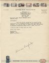
| Description: | Letterhead of the Dayton Pump Products Company of Belgium, Wisconsin, distributor of Dayton Water Systems, with six vignettes of water systems in use: wate... |
| Date: | |
|---|---|
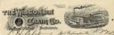
| Description: | Memohead of the Wisconsin Chair Company of Port Washington, Wisconsin, with its McLean patented swing rocking chair set against a circular background with ... |
| Date: | |
|---|---|
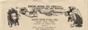
| Description: | Letterhead of the West Side Fuel Company of Port Washington, Wisconsin, with cartoon-style drawings, printed in black ink, of workers mining coal with a pi... |
If you didn't find the material you searched for, our Library Reference Staff can help.
Call our reference desk at 608-264-6535 or email us at: