 Filter: Categories of Wisconsin Historical Images
Filter: Subject of Water
Filter: County of Oconto
Filter: Categories of Wisconsin Historical Images
Filter: Subject of Water
Filter: County of Oconto

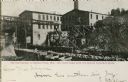
| Date: | 1930 |
|---|---|
| Description: | Holt Lumber Company sawmill, built in 1840. |
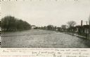
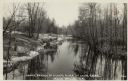
| Date: | 1906 |
|---|---|
| Description: | Oconto River, looking north. Caption reads: "Scene on Oconto River, Looking North, Oconto, Wis." |
| Date: | 1900 |
|---|---|
| Description: | Footbridge on river. Caption reads: "The Foot Bridge at Oconto, Wis., That went down with the Oconto Freshman Class." |
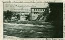
| Date: | 1908 |
|---|---|
| Description: | Falls of the Oconto River with footbridge. Caption reads: "The Falls at Oconto Falls, Wis." |
| Date: | 1856 |
|---|---|
| Description: | View across water toward the sawmill and various outbuildings located on the Oconto River. Steam is rising from a large pipe over over the main building, a... |
| Date: | |
|---|---|
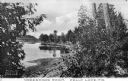
| Description: | View of the tree-lined shore of Kelly Lake. Caption reads: "Underwood Point, Kelly Lake, Wis." |

| Date: | 1870 |
|---|---|
| Description: | View of two lakeside cottage, which have docks and porches that overlook the lake. Caption reads: "Birch Walk, Kelly Lake, Wis." |
| Date: | 1856 |
|---|---|
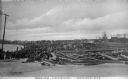
| Description: | Large piles of logs waiting to be processed into lumber sit next to the Oconto River. In the background stand what appear to be piles of cut lumber. Captio... |
| Date: | 1870 |
|---|---|
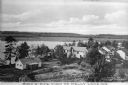
| Description: | Elevated view of cottages along Kelly Lake's shoreline. Some of the buildings are two-story structures. Trees stand between the cottages and line the lake'... |
| Date: | 1870 |
|---|---|
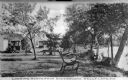
| Description: | View toward three cottages along the tree-lined shore of Kelly Lake at Underwood Point. Small docks with boats are along the shoreline. A wooden bench with... |
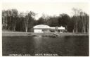
| Date: | 1945 |
|---|---|
| Description: | Photographic postcard of the Tip Top Dance Pavillion on Anderson Lake. The view from the lake shows several automobiles parked outside the pavillion. The s... |
| Date: | |
|---|---|
| Description: | Photographic postcard view up the river. The trees along the shoreline are reflected in the water. Caption reads: "North Branch of the Oconto River at Chut... |
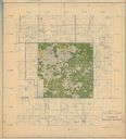
| Date: | |
|---|---|
| Description: | This hand-colored map shows the Ranger District boundaryin blue, government lands in green, and "Opt. 9 Appr. Land" in yellow. |

| Date: | 1886 |
|---|---|
| Description: | This map, originally published in the 1881 Illustrated historical atlas of Wisconsin, shows the township and range system, sections,towns, cities and villa... |
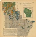
| Date: | 1920 |
|---|---|
| Description: | This map shows the township and range system, sections, cities and villages, railroads, roads, and streams and lakes in Oconto County, Wisconsin. Color co... |

| Date: | 1922 |
|---|---|
| Description: | This map from the early to mid-20th century shows the township and range system, towns, cities and villages, roads, railroads, schools, churches, cemeterie... |

| Date: | 1908 |
|---|---|
| Description: | This early 20th century map shows the township and range system, sections, state-owned land, selected buildings and landownership, railroads, bridges, and ... |

| Date: | 1922 |
|---|---|
| Description: | This map from the early to mid-20th century shows the township and range system, towns, cities and villages, roads, railroads, schools, churches, and lakes... |

| Date: | 1935 |
|---|---|
| Description: | This map shows streets, railroads, and city wards. Streets, the Oconto River, and the Green Bay are labeled. The bottom of the map reads: "Compliments of O... |
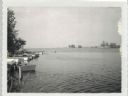
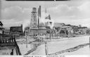
| Date: | 07 21 1960 |
|---|---|
| Description: | View from Oconto looking out into Green Bay Channel, which is often too shallow between the log pilings and lighthouse. Boats and docks are docked along th... |
If you didn't find the material you searched for, our Library Reference Staff can help.
Call our reference desk at 608-264-6535 or email us at: