Filter: Categories of Wisconsin Historical Images
Filter: Subject of Water
Filter: County of Milwaukee
Filter: Categories of Wisconsin Historical Images
Filter: Subject of Water
Filter: County of Milwaukee
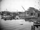
| Date: | 10 28 1938 |
|---|---|
| Description: | Docks and shanties at Jones Island, with smokestacks and cranes in the background. |
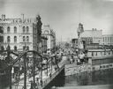
| Date: | 1900 |
|---|---|
| Description: | View looking up Wisconsin Avenue from the bridge. Many pedestrians, streetcars, and horse-drawn vehicles are visible. |

| Date: | 04 01 1975 |
|---|---|
| Description: | The bridge over the Milwaukee Harbor named in honor of former Mayor Daniel Hoan. The bridge was constructed between 1970 and 1972, but during the period de... |

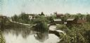
| Date: | 1876 |
|---|---|
| Description: | Made from U.S. Surveys and from minutes furnished by Jos. S. Buck and Dr. C. Chase. Scale 20 CHs to an inch. |

| Date: | 1882 |
|---|---|
| Description: | This basic reference map of the state shows natural features, railroads, county seats, and political boundaries against the G.L.O. township and range grid.... |
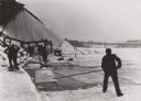
| Date: | 1910 |
|---|---|
| Description: | Poling ice blocks to the hoist on the Milwaukee River. |

| Date: | 1906 |
|---|---|
| Description: | Polyconic projection. Map made from surveys without spirit level control. Henry Gannett, Chief Topographer. Topography by Van H. Manning and Nat. Tyler, Jr... |

| Date: | 1908 |
|---|---|
| Description: | Colored map in perspective indicates railroad routes. Lake Winnebago and Oshkosh in center, area extends to Shawano (top right corner), Green Bay (bottom r... |

| Date: | 1895 |
|---|---|
| Description: | Panoramic view of Milwaukee looking northeast. City Hall is visible at the left and Lake Michigan can be seen at the upper right. |

| Date: | 1853 |
|---|---|
| Description: | Plan no. 3. Scale 2000 feet to one inch. |
| Date: | 07 13 1915 |
|---|---|
| Description: | Looking south from Wells Street. A boat travels along the Milwaukee River in the foreground. Landmarks left to right: Manufacturers Home Building, First Na... |
| Date: | |
|---|---|
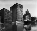
| Description: | Elevated view of the Milwaukee commercial district looking north over the Milwaukee River from the Michigan Street bridge. Landmarks right to left: Pabst B... |
| Date: | 1903 |
|---|---|
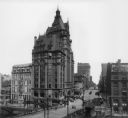
| Description: | Elevated view from Wisconsin River looking east. The Pabst Building is on the northwest corner of N. Water Street and E. Wisconsin Avenue with the Mack bui... |
| Date: | 08 06 1917 |
|---|---|
| Description: | Chicago and North Western Railrod depot at the east end of Wisconsin Avenue. Caption on glass plate reads: "South end of Juneau Park extention [sic]... |
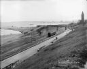
| Date: | 08 06 1917 |
|---|---|
| Description: | Overlooking the Chicago and North Western railroad depot from Juneau Park bluff. Caption on glass plate reads: "Extention [sic] of Juneau Park, show... |
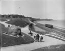
| Date: | 05 30 1914 |
|---|---|
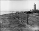
| Description: | Juneau Park looking north from approximately E. Mason Street, with the Chicago and North Western railroad tracks on the right. The Lake Michigan shoreline ... |
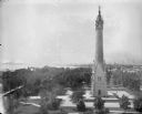
| Date: | 06 19 1902 |
|---|---|
| Description: | Elevated view of the North Point Water Tower at the foot of E. North Avenue. |

| Date: | 1854 |
|---|---|
| Description: | Bird's-eye illustration of Milwaukee. |

| Date: | |
|---|---|
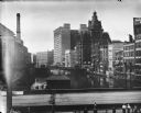
| Description: | Elevated view southeast from the courthouse at E. Kilbourn Avenue and N. Jackson Street. The Northwestern Mutual home office building and Chicago and North... |
If you didn't find the material you searched for, our Library Reference Staff can help.
Call our reference desk at 608-264-6535 or email us at: