 Filter: Categories of Wisconsin Historical Images
Filter: Subject of Water
Filter: County of Bayfield
Filter: Year of 1900-1999
Filter: Year of 1970-1979
Filter: Categories of Wisconsin Historical Images
Filter: Subject of Water
Filter: County of Bayfield
Filter: Year of 1900-1999
Filter: Year of 1970-1979

| Date: | 1971 |
|---|---|
| Description: | A topgraphical map of Cable, Wisconsin showing railroads. |

| Date: | 1971 |
|---|---|
| Description: | A topographical map of Namekagon Lake and the surrounding area. |
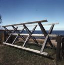
| Date: | 1978 |
|---|---|
| Description: | A wooden fishing net rack sitting on the grass near the shoreline of Lake Superior. |
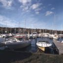
| Date: | 10 1978 |
|---|---|
| Description: | View from shoreline towards motorboats and sailboats docked in a marina. In the distance are buildings on a hill among trees. |

| Date: | 1971 |
|---|---|
| Description: | A topographical map of the Grand View NW quadrangle. |
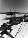
| Date: | 1976 |
|---|---|
| Description: | Fishing boats wintering on Lake Superior, which is frozen and covered with snow. Wooden fishing boxes are strewn in the foreground, and a wooded shoreline ... |
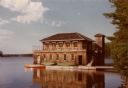
| Date: | 1978 |
|---|---|
| Description: | Two-story vertical log boathouse on Lake Namakagan. Two canoes are on the boathouse deck and a red canoe is in the lake tied to the deck. Both floors of th... |
If you didn't find the material you searched for, our Library Reference Staff can help.
Call our reference desk at 608-264-6535 or email us at:
