 Filter: Categories of Wisconsin Historical Images
Filter: Subject of Water
Filter: County of Bayfield
Filter: Year of 1900-1999
Filter: Year of 1900-1909
Filter: Categories of Wisconsin Historical Images
Filter: Subject of Water
Filter: County of Bayfield
Filter: Year of 1900-1999
Filter: Year of 1900-1909
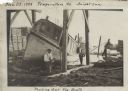
| Date: | 1904 |
|---|---|
| Description: | View across water towards Brower Park near Houghton Point. |
| Date: | 1900 |
|---|---|
| Description: | View of Hougton Point and Bayfield from Madeline Island. |

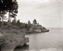
| Date: | 1909 |
|---|---|
| Description: | Postcard of the overhanging cliffs near the stone quarry on Presque Isle or Stockton Island's. Caption reads: "Apostle Islands, Wis. Presque Isle or Stockt... |

| Date: | 1900 |
|---|---|
| Description: | This 1900 map shows the township and range system, sections, cities and villages, railroads, roads, vacant land and land sold by the Wisconsin Central Rail... |

| Date: | 1906 |
|---|---|
| Description: | This 1906 map of Bayfield County, Wisconsin, shows towns, sections, cities, villages and post offices, land ownership, wagon roads, railroads, schools, gov... |
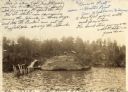
| Date: | 11 29 1908 |
|---|---|
| Description: | Men working on pulling the boat "Fish Hawk" out of the water. One man is kneeling in front of the boat and looking at the camera. A man in the background i... |

| Date: | 1900 |
|---|---|
| Description: | Cove Logging camp at future site of Forest Lodge property. The log building on the hill became the main house at Forest Lodge in 1902 when Crawford Livings... |
If you didn't find the material you searched for, our Library Reference Staff can help.
Call our reference desk at 608-264-6535 or email us at: