Filter: Categories of Wisconsin Historical Images
Filter: Subject of Water
Filter: County of Ashland
Filter: Subject of human settlements
Filter: Categories of Wisconsin Historical Images
Filter: Subject of Water
Filter: County of Ashland
Filter: Subject of human settlements
| Date: | 1920 |
|---|---|
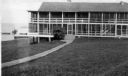
| Description: | View across lawn of the Mission Inn on Madeline Island, with a shoreline on the left. |
| Date: | 1917 |
|---|---|
| Description: | Elizabeth Lathrop, Post Mistress, stands with a dog and other people in front of the Post Office. There is a shoreline on the left. |

| Date: | 1910 |
|---|---|
| Description: | View of La Pointe taken from Big Bay Road on Madeline Island. |
| Date: | 1912 |
|---|---|
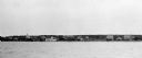
| Description: | Elevated view of La Pointe dock taken from the water. |

| Date: | 1900 |
|---|---|
| Description: | View of La Pointe, Madeline Island, taken from the Mission Inn. |

| Date: | 1900 |
|---|---|
| Description: | The house of Captain Angus on the shore of Lake Superior in La Pointe on Madeline Island sometime around 1900. The Angus family came to Madeline Island in ... |

| Date: | 1886 |
|---|---|
| Description: | Bird's-eye view of Ashland, on the shores of Lake Superior, with insets of The Apostle Islands Chequamagon Bay & Ashland, and Distances from Ashland. |

| Date: | 1898 |
|---|---|
| Description: | Old Mission Residence at La Pointe, Madeline Island. |
| Date: | 1930 |
|---|---|
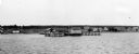
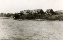
| Description: | View from water of cottages along the shoreline in Nebraska Row, La Pointe, Madeline Island. Caption reads: "Nebraska Row — La Pointe, Wis." |

| Date: | 1890 |
|---|---|
| Description: | Bird's-eye map of Ashland, viewed from Lake Superior, with insets of Prentice Park and Fishery. Population 16,000. Increase in Ten Years, 11,000. |
| Date: | 1891 |
|---|---|
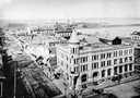
| Description: | Elevated view looking west from the Knight Block. The Chequamegon Hotel and harbor are in the background. |

| Date: | 1885 |
|---|---|
| Description: | Mining and lumbering provided the impetus for the development of northern Wisconsin and Ashland was ideally situated to become a leading city of the "new W... |

| Date: | 02 26 1887 |
|---|---|
| Description: | Bird's-eye map of Ashland, and the Apostle Islands in Lake Superior. Caption reads: "Ashland and the Apostle Islands." |

| Date: | 1885 |
|---|---|
| Description: | Ore dock of the Milwaukee, Lake Shore, and Western Railroad, with a pile of logs in the foreground and docked ships in the background. |

| Date: | |
|---|---|
| Description: | Looking West from Knight Block, with shipping piers and sailing ships on right side, railroad on left, trees in background. Horse-drawn carriages on street... |
| Date: | |
|---|---|
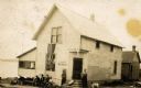
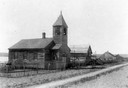
| Description: | Exterior view of Presbyterian Church with dirt path in front and wooden buildings in the background. |

| Date: | 1884 |
|---|---|
| Description: | Panorama bird's-eye view of the town of Ashland, on Lake Superior, and the Apostle Islands. |
| Date: | 1955 |
|---|---|
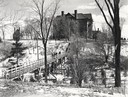
| Description: | Wheeler Hall at Northland College, during winter. A group of people are on a bridge over the Bay City Creek, surrounded by trees, in the foreground. Wheele... |

| Date: | 1885 |
|---|---|
| Description: | View of the ore dock of the Milwaukee, Lake Shore, and Western Railroad. Large logs, buildings and a railroad bridge are in the foreground. |
If you didn't find the material you searched for, our Library Reference Staff can help.
Call our reference desk at 608-264-6535 or email us at: