Filter: Categories of Wisconsin Historical Images
Filter: Subject of Water
Filter: Community of Sheboygan
Filter: Categories of Wisconsin Historical Images
Filter: Subject of Water
Filter: Community of Sheboygan

| Date: | 1885 |
|---|---|
| Description: | Bird's-eye view of Sheboygan, with inset of J.J. Volrath Manufacturing Company. |

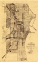
| Date: | 1914 |
|---|---|
| Description: | This map shows Sheboygan in 1914. The top of the map has the date of "NOV 17 1916" stamped in red ink. The map shows numbered plots and labeled streets, an... |
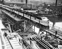
| Date: | 05 03 1948 |
|---|---|
| Description: | Elevated view of a Chicago and Northwestern passenger train, which is the first across a new bridge in Sheboygan. There is a group of people standing near ... |
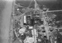
| Date: | 1930 |
|---|---|
| Description: | Aerial view of the construction of the Wisconsin Power and Light Company power plant on the shore of Lake Michigan. |
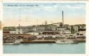
| Date: | 1925 |
|---|---|
| Description: | View across water towards the Phoenix Chair factory on the waterfront. Caption reads: "Phoenix Chair Factory, Sheboygan, Wis." |

| Date: | 1909 |
|---|---|
| Description: | Elevated view of town on Lake Michigan. Caption reads: "Sheboygan, Wis. North Point on Lake Michigan." |

| Date: | |
|---|---|
| Description: | View from shoreline towards a passenger train crossing a bridge near the Sheboygan Mineral Water Company Bottling Works building. Caption reads: Passenger ... |

| Date: | 1857 |
|---|---|
| Description: | This map of Sheboygan Harbor shows the river mouth and harbor, piers, wharfs, piles of old destroyed bridge wharfs, streets, and the lake shore from survey... |

| Date: | 1836 |
|---|---|
| Description: | This 1836 map consists chiefly of a detailed map of the the mouth of the Sheboygan River. An inset map of the region and cross section diagrams of the pier... |
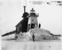
| Date: | |
|---|---|
| Description: | Three men pose standing on ice around North Pier lighthouse. In the background is the town along the shoreline. |

| Date: | 1938 |
|---|---|
| Description: | Small child standing on the shoreline of a sandy beach, looking out at the waves, at Terry Andrae State Park on Lake Michigan. |

| Date: | 1921 |
|---|---|
| Description: | This map is part of the survey of the northern and northwestern lakes. The map shows Sheboygan Harbor on the shore of Lake Michigan and the Sheboygan River... |
| Date: | 1935 |
|---|---|
| Description: | This map created by the Sheboygan City Engineer department shows five different types of land use in the city in 1935. A legend in the bottom right corner ... |

| Date: | 1840 |
|---|---|
| Description: | This is a plat map of Sheboygan showing the Sheboygan River and Lake Michigan. Streets are labeled and plats are numbered in quadrants. Some points of inte... |
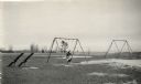
| Date: | |
|---|---|
| Description: | Recreational grounds near the beach at Terry Andrae State Park. A woman and a child are on a swing set. There are teeter totters on the left. |
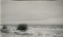
| Date: | |
|---|---|
| Description: | White sand and breaking waves along the beach at Terry Andrae State Park. |
| Date: | |
|---|---|
| Description: | Beach at Terry Andrae State Park. There is a wooden boardwalk in the foreground. |

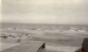
| Date: | |
|---|---|
| Description: | View along shoreline showing the wide sandy swimming beach along Lake Michigan at Terry Andrae State Park. Two people are on the shoreline. |
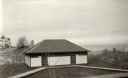
| Date: | |
|---|---|
| Description: | The bathhouse and wooden boardwalks at the swimming beach, Terry Andrae State Park. |
If you didn't find the material you searched for, our Library Reference Staff can help.
Call our reference desk at 608-264-6535 or email us at: