 Filter: Categories of Wisconsin Historical Images
Filter: Subject of Water
Filter: Community of Mazomanie
Filter: Categories of Wisconsin Historical Images
Filter: Subject of Water
Filter: Community of Mazomanie

| Date: | 1875 |
|---|---|
| Description: | Bird's-eye map of Mazomanie. |

| Date: | 1874 |
|---|---|
| Description: | Distant view of the town from a hill with houses, garden plots, businesses and churches. |

| Date: | 1910 |
|---|---|
| Description: | Elevated view of Mazomanie. The church's steeple stands out in the landscape of houses and barns. |

| Date: | |
|---|---|
| Description: | A path along railroad tracks on the left and a river on the right. Tall bushes are along the river. Trees and a fence are to the left lining the railroad t... |

| Date: | |
|---|---|
| Description: | Elevated view of Lake Marion, and the railroad tracks that run along it on the left. A train belching smoke is coming up the tracks. A road runs along the ... |

| Date: | |
|---|---|
| Description: | Elevated view from hill looking down at a river and reservoir. A railroad train is moving along railroad tracks on the opposite side of the river. Houses a... |

| Date: | |
|---|---|
| Description: | View from road of parsonage. There is a porch on the right side, and a hand-pump on the back stoop of a smaller, one-story section of the parsonage in the ... |
| Date: | |
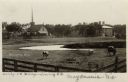
|---|---|
| Description: | View across fence towards a pasture with cows. A stream is running through the pasture, and in the background behind a fence are buildings and a church amo... |
If you didn't find the material you searched for, our Library Reference Staff can help.
Call our reference desk at 608-264-6535 or email us at: