 Filter: Categories of Wisconsin Historical Images
Filter: Subject of Water
Filter: Community of Madison
Filter: Subject of trails
Filter: Categories of Wisconsin Historical Images
Filter: Subject of Water
Filter: Community of Madison
Filter: Subject of trails
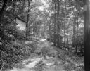
| Date: | 06 27 1931 |
|---|---|
| Description: | Path, "main street," through the woods at the University of Wisconsin Tent Colony. Also known as Camp Gallistella on the south shore of Lake Mendota, west ... |
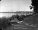
| Date: | 1926 |
|---|---|
| Description: | Lake Mendota, including Fraternity Row and east side shoreline, taken from the lake path on University Bay Drive. |
| Date: | 1926 |
|---|---|
| Description: | View of Adams, Tripp and Van Hise Halls. All are residence halls on the University of Wisconsin campus with Picnic Point and Lake Mendota in the backgroun... |

| Date: | 1907 |
|---|---|
| Description: | The Yahara River Parkway, with the old Lapham School at 1436 East Dayton Street at North Thornton visible on the righthand side. |

| Date: | 1906 |
|---|---|
| Description: | View from shoreline looking over a pathway towards the Steensland Bridge and Yahara River Parkway at East Washington Avenue. |

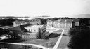
| Date: | 1907 |
|---|---|
| Description: | Elevated view looking northeast from the chimney of the Power Plant on University Avenue. The Chemistry Building is in the foreground, and Bascom Hall and ... |

| Date: | 1907 |
|---|---|
| Description: | Elevated view looking northeast from the chimney of the Power Plant on University Avenue. The Chemistry Building is in the foreground, and Bascom Hall and ... |

| Date: | 1929 |
|---|---|
| Description: | Elevated panoramic view towards the northeast from the tower of the Congregational Church of the University of Wisconsin-Madison campus, with Lake Mendota ... |

| Date: | 1974 |
|---|---|
| Description: | This 1974 map is a reproduction of the original survey maps of the Four Lakes region of Dane County, Wisconsin. It shows sections, lakes, rivers, wetlands,... |

| Date: | 1970 |
|---|---|
| Description: | Map features a legend of roads, trails, points of interest, buildings, and types of vegetation. To the right are "ARBORETUM REGULATIONS" regarding hours, p... |

| Date: | 1900 |
|---|---|
| Description: | View from path of a footbridge over the lagoon in Tenney Park. A man is walking along the path on the right. Trees are along the shoreline. |
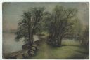
| Date: | |
|---|---|
| Description: | Oil painting of a double row of willow trees on University Bay Drive. A trail winds between them. Boulders line the shore of Lake Mendota on the left. A tu... |

| Date: | |
|---|---|
| Description: | Elevated view over flowering trees of the Yahara Parkway. The Yahara River is on the left and a path runs along it on the right. Caption reads: "Yahara Pa... |

| Date: | |
|---|---|
| Description: | Elevated view from shoreline of the Yahara River, with a path running along the shoreline on the left, and a bridge in the distance. Boats are docked near ... |
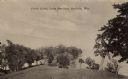
| Date: | |
|---|---|
| Description: | Sepia-toned photographic postcard view looking out towards the Picnic Point Peninsula jutting out into Lake Mendota. A walking path is on the left Caption ... |

| Date: | |
|---|---|
| Description: | View down the Yahara River towards where it enters Lake Monona at Yahara Park. There are a few houses on either side of the river. Caption reads: "Yahara R... |

| Date: | 1902 |
|---|---|
| Description: | A view across Lake Mendota from Tenney Park. A group of four children are on the near shoreline. A group of adults are standing and sitting in the midgroun... |
If you didn't find the material you searched for, our Library Reference Staff can help.
Call our reference desk at 608-264-6535 or email us at: