 Filter: Categories of Wisconsin Historical Images
Filter: Subject of Water
Filter: Community of Madison
Filter: Subject of public utilities
Filter: Categories of Wisconsin Historical Images
Filter: Subject of Water
Filter: Community of Madison
Filter: Subject of public utilities

| Date: | 12 14 1976 |
|---|---|
| Description: | View of Lake Mendota and shoreline from University Bay Drive. Snow covers the lake and the shore. |
| Date: | 1910 |
|---|---|
| Description: | A woman crosses Monona Avenue as a man on a bicycle rides by. The large, Second Empire style Avenue Hotel, with two-story porch, is on the left; the GAR ha... |

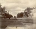
| Date: | 1903 |
|---|---|
| Description: | This map is ink on printed paper reading: "standard profile plate." "Surveyed Oct. 15, platted Dec. 15, 1903 ; surveyed May 9, platted Dec. 9." |
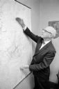
| Date: | 08 13 1965 |
|---|---|
| Description: | H.O. Lord, Madison Metropolitan Sewerage District chief engineer, outlining the existing sewerage district on a map. Lord is trying to educate the public c... |

| Date: | |
|---|---|
| Description: | View across water towards the shoreline of the eastern isthmus of Madison, including the MG&E power plant smokestacks. A group of people appear to be fishi... |
If you didn't find the material you searched for, our Library Reference Staff can help.
Call our reference desk at 608-264-6535 or email us at: