 Filter: Categories of Wisconsin Historical Images
Filter: Subject of Water
Filter: Community of Madison
Filter: Subject of farms
Filter: Categories of Wisconsin Historical Images
Filter: Subject of Water
Filter: Community of Madison
Filter: Subject of farms
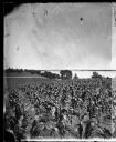
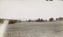
| Date: | 1875 |
|---|---|
| Description: | View from Southeast shore of Lake Monona across a cornfield, perhaps on the farm of Thomas Williamson. |

| Date: | 03 24 1913 |
|---|---|
| Description: | Picnic Point from the University Farm fields, now known as Observatory Hill. |
| Date: | 1930 |
|---|---|
| Description: | Aerial view of Turville Point and Turville farm, Lake Monona. |
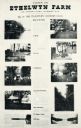
| Date: | |
|---|---|
| Description: | Ethelwyn Farm (The Teachers' Country Club), on Lake Monona. |
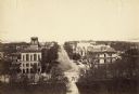
| Date: | 1887 |
|---|---|
| Description: | Elevated view of Wisconsin Avenue from the Wisconsin State Capitol building. Mansions and churches are along the road, and Lake Mendota and Picnic Point ar... |

| Date: | 1956 |
|---|---|
| Description: | Aerial view over University Avenue of the University of Wisconsin-Madison campus, including University farm in the upper middle. The shoreline of Lake Mend... |
| Date: | 1958 |
|---|---|
| Description: | Aerial View of Eagle Heights Apartments, built especially for married students' housing, under construction on the University of Wisconsin-Madison campus. ... |

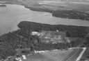
| Date: | 07 15 1958 |
|---|---|
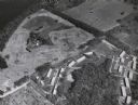
| Description: | Aerial view of Eagle Heights Farm, Eagle Heights Woods and part of Lake Mendota. Sites labeled on the image are Eagle Heights, Tent Colony, Apartment Site,... |
| Date: | 1900 |
|---|---|
| Description: | View downhill through pastures towards the northwest looking across Lake Mendota's University Bay with Picnic Point in the background. |

| Date: | 1871 |
|---|---|
| Description: | This map shows buildings, roads, the railroad, an orchard, and swamp land. Relief shown by hachures. The map includes an index of buildings in the upper ri... |

| Date: | |
|---|---|
| Description: | Cattle walk at the edge of a pond at Baywood Farm. There are buildings in the background among the trees. |

| Date: | 1913 |
|---|---|
| Description: | This photocopy map shows plots with owners' names, land use both commercial and agricultural, and lot outlines on University land. Lake Mendota is labeled ... |

| Date: | 06 30 1895 |
|---|---|
| Description: | A man is standing in the right foreground near a tall plant, perhaps corn. In the center is a square-shaped pond with high banks. A man is in the backgroun... |
If you didn't find the material you searched for, our Library Reference Staff can help.
Call our reference desk at 608-264-6535 or email us at: