Filter: Categories of Wisconsin Historical Images
Filter: Subject of Water
Filter: Community of Galesville
Filter: Categories of Wisconsin Historical Images
Filter: Subject of Water
Filter: Community of Galesville
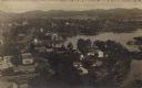
| Date: | 1900 |
|---|---|
| Description: | This maps shows part of Galesville, Trempealeau County, Wisconsin. The map shows lots for sale, local streets, and part of Lake Marinuka. Lots are numbered... |

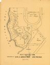
| Date: | 1955 |
|---|---|
| Description: | This blue line print shows streets, fair grounds, schools, parks, and a cemetery. Streets, points of interest, and Lake Marinuka are labeled. The middle le... |
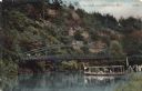
| Date: | |
|---|---|
| Description: | View of a cliff overlooking a river. A group of people is gathered on the bank waiting to board an excursion boat. There is a bridge in the background. |
If you didn't find the material you searched for, our Library Reference Staff can help.
Call our reference desk at 608-264-6535 or email us at: