Filter: Categories of Wisconsin Historical Images
Filter: Subject of Water
Filter: Community of Baraboo
Filter: Categories of Wisconsin Historical Images
Filter: Subject of Water
Filter: Community of Baraboo
| Date: | 1921 |
|---|---|
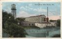
| Description: | Colorized postcard view of the exterior of the woolen mill along the banks of a river. A water tower is on the left, and a smokestack is on the right. Capt... |
| Date: | 1898 |
|---|---|
| Description: | Colorized postcard view of the Devil's Doorway rock formation overlooking Devil's Lake. Caption reads: "Devil's Doorway, Devil's Lake, Wis." |
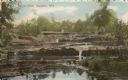
| Date: | |
|---|---|
| Description: | Colorized postcard view of Skillet Falls from downstream. Caption reads: "Skillet Falls, Baraboo, Wis." |
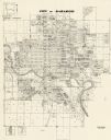
| Date: | 1972 |
|---|---|
| Description: | This map shows plat of the city, city limits, local streets, and part of the Baraboo River. The map includes 3 inset maps. |

| Date: | 1975 |
|---|---|
| Description: | This map shows plat of the city, city limits, local streets, and part of Baraboo River. The map includes 2 inset maps and a legend showing residential, bus... |
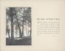
| Date: | 1920 |
|---|---|
| Description: | A hand-tinted photograph of a scene along the wooded shore of Devil's Lake is mounted on a piece of beige paper. The scene features an old section of a woo... |
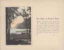
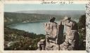
| Date: | 1920 |
|---|---|
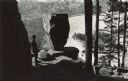
| Description: | A hand-tinted photograph of a tree-framed scene along the shore of Devil's Lake is mounted on a piece of beige paper. A large bluff dominates the backgroun... |

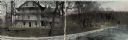
| Date: | 04 1973 |
|---|---|
| Description: | View across water through trees towards a house above the banks of the flooded Baraboo river. |

| Date: | 1910 |
|---|---|
| Description: | View from shoreline of boats, including an excursion boat, on the shoreline and along both sides of a pier. There are three men on the pier at Kirkland Lan... |
| Date: | 1910 |
|---|---|
| Description: | Color enhanced black and white photographic postcard, a double length panorama of the Lake View Hotel. The lake shore is stabilized with a rock wall and a ... |
| Date: | |
|---|---|
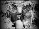
| Description: | View looking down at Skillet Creek Falls, which are surrounded by rocks, trees and foliage. Skillet Creek, located on private land, flows to Pewit's Nest, ... |
| Date: | |
|---|---|
| Description: | Elevated view of a man standing on a rock looking over a frozen Devil's Lake in front of a Balanced Rock. Original caption: "There are some startling rock ... |

| Date: | 1949 |
|---|---|
| Description: | This map shows points of interest, historic sites, buildings, trails, roads, and general animal and plant locations. |

| Date: | 1903 |
|---|---|
| Description: | This blue line print shows quartzite areas, mines, railroads, and roads. The map covers townships 11-13 north, ranges 4-8 east, in parts of Sauk and Columb... |
| Date: | 1898 |
|---|---|
| Description: | Colorized postcard of an elevated view of the Devil's Doorway rock formation at Devil's Lake State Park. Devil's Lake is below in the background. Caption r... |

| Date: | |
|---|---|
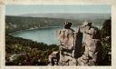
| Description: | Colorized postcard of an elevated view of the rock formation near Devil's Lake. Caption at top reads: "Prospect Point, 610 FT. Above the Lake." Caption at ... |

| Date: | 1908 |
|---|---|
| Description: | Colorized postcard view of the Cleopatra's Needle rock formation, with Devil's Lake in the background. Caption reads: "Cleopatra's Needle, Devils [sic] La... |

| Date: | |
|---|---|
| Description: | A man poses on a rock formation named "Devil's Doorway" at Devil's Lake State Park. The lake is visible in the background. |
| Date: | 1935 |
|---|---|
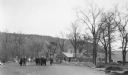
| Description: | Men wearing hats and long overcoats are walking toward the camera from the bathhouse at Devil's Lake State Park. Other men in work clothes, members of the ... |
If you didn't find the material you searched for, our Library Reference Staff can help.
Call our reference desk at 608-264-6535 or email us at: